As we
approached our 37th wedding anniversary, we decided that we would ‘gift’
ourselves with a 3 day exploration of southwestern Virginia. Most of our recent forays into that portion
of the state had been right along I-81 to its interchange with I-77. From there it was the super slab all the way
to the Cleveland area where our son and his family used to live…
So I
planned a route off the beaten path in Virginia wandering 2-lane highways for
the most part, eventually arriving in Roanoke where we spent a couple of
nights.
We
jumped off of I-81 at Abingdon Virginia and took US Hwy. 58 east toward the
Blue Ridge Parkway. I wouldn’t recommend
parts of this highway to anyone driving or pulling a big recreational vehicle…
It winds and twists through the mountains in several areas.
The
Green Cove Railroad Station serves as a U.S. Forest Service Visitor Center and
trailhead for the Virginia Creeper Trail.
The Green Cove Station is the only original remaining depot building along
the Virginia Creeper Trail. The depot
has also served as a post office, general store, and freight office. Green Cove Station was built by the Norfolk
and Western Railroad in 1914. This rail
line became known as the Virginia Creeper because of the train’s slow speed as
they went up and over the mountains.
This
photograph engraved in stone sits near the front of the Green Cove
Station. It is copied from an original
photo by O. Winston Links who is famous for capturing the end of the ‘golden
age’ of the railroads in the USA.
The
last train that stopped here, an excursion train, was back in 1977. In that year flooding severely damaged the
line and it was never repaired. Today, the Virginia Creeper Trail is a 35-mile multi-purpose
‘rail trail’ that stretches from Abingdon to Whitetop Virginia…through National
Forest and crossing numerous restored trestles as well as the Appalachian
Trail. There was a large group of
bicyclists at the depot, (which wasn’t open), when we stopped by.
To
learn more about the Virginia Creeper ‘rail trail’ just go to http://www.vacreepertrail.com/.
One
sight of note as we drove along the flanks of the Mount Rogers National
Recreation Area was the large number of Christmas tree farms! It was unexpected, that’s for sure. When I checked on the Internet, I was amazed
at the number of members listed on the roster of the Virginia Christmas Tree
Growers Association. Check it out at http://www.virginiachristmastrees.org/farmlisting/.
One
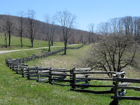
rarely sees a split rail fence like this in this day and age… They are
sometimes also referred to as a zigzag fence, worm fence or snake fence. These fences are very simple in their
construction, and can be assembled with few tools even on hard or rocky ground.
They also can be built without using any
nails or other hardware. This hardware
was often scarce and expensive in frontier areas. They were particularly popular in very rocky
areas where post hole digging is almost impossible.
The scenery
along US Hwy. 58 is just beautiful! As I
mentioned above, the highway passes through the Mount Rogers National
Recreation Area. The highest point in
this national recreation area and in the state of Virginia is, appropriately
enough, Mt. Rogers at 5,729 feet.
The Mt.
Rogers National Recreation Area is 1 of only 18 in the USA. It covers almost 200,000 acres, contains 4 federally
designated Wilderness Areas, has 11 camp sites, (4 of which are set up as horse
camps), and over 500 miles of hiking trails.
For those of us who aren’t into hiking, there is also the Mt. Rogers
Scenic Byway. This federally protected
area has over 1,000,000 visitors each year.
We love
waterfalls, even modest man-made versions.
This peaceful low rise dam is on a tributary of the New River near
Independence Virginia.
The
Grayson County Courthouse is located in Independence Virginia. This ‘new’ courthouse was built in 1908 to
replace an 1850 building. To say that
this structure is eclectic would be an understatement. Note the Flemish gable flanked by turrets.
In 1979
the county opened a new courthouse. This
1908 building now serves as an area art and cultural center. It is operated by the Historic 1908
Courthouse Foundation, and houses the Grayson Crossroads Museum, Baldwin Auditorium,
Treasury Gift Shop, and some business offices as well.
The
population of Independence was only 947 at the 2010 census. The town is home to a major town celebration
on July 4 every year, which is held in front of the courthouse. It features bluegrass and old-time music and
dance, food, crafts and a wild pony sale. The courthouse is also the location of the
Mountain Foliage Festival. That fall festival
features a parade, crafts, arts and music, as well as a race in which
contestants use outhouses…i.e., “The Grand Privy Race”.
That’s
about it for now… Just click on the photos if you’d like to enlarge them.
Thanks
for stopping by for a drive through the mountains!
Take
Care, Big Daddy Dave


Looks like a great little tour of a pretty area. Pretty amazing that the county seat only has 900 folks.
ReplyDelete