I
frequently focus on historical places or sites but usually they are now
museums, homes, re-purposed buildings.
But on this occasion the site is actually still serving its original
purpose…or will be again in the near future!

This is
a photo that I borrowed from the Internet.
This is Chilhowee Dam on the Little Tennessee River. Dam Construction on this dam began in 1955
and was completed in 1957. The dam's
reservoir covers approximately 1,734 acres at normal full pool and has a
drainage area of 1,977 square miles. The
elevation of Chilhowee Reservoir is 874 feet above sea level.
The
Chilhowee Dam was added to the National Register of Historic Places at some
point…but I was unable to determine exactly why it is on the Register.

The
Chilhowee Dam was the 4th and final dam built on the Little
Tennessee River and it’s tributaries in the Smoky Mountains that was
specifically designed to provide the necessary power for the operation of Alcoa
Aluminum’s operations in East Tennessee.
The other dams in this group include the Calderwood, Cheoah and
Santeetlah.
So why
was the dam drawn down? Actually it was
for a damn good reason! The earthen
portion of the dam on the far side of the above photo had developed a leak…or,
as the contractor phrased it, a 38 foot sinkhole! In time it would have undermined that part of
the dam, sending a serious wall of water down river… Of course, with continuous
monitoring, that wouldn’t have happened.
This is
a challenging project. From what I could
determine, there has been seepage for some time and there was another drawdown
back in 2008. To check out the project’s
issues, specifications and scope of work, go to https://www.tn.gov/assets/entities/environment/attachments/ppo_water_nrs16-207.pdf.

In any
case, our visit to the Chilhowee Dam was prompted by our ‘funky tasting’
water. Our water supply here in East
Tennessee always tasted great until this summer. A long streak of 90 degree days, warmer than
usual water temperatures, combined with problems at our water treatment plants
caused a minor uproar in the area. Laurie,
my better half, started digging into the problem and she discovered that the
root cause of the funky/moldy tasting water was the drawdown of the Chilhowee
Reservoir. Without going into the
details, that action started a chain of events that led to the foul tasting although
“safe to drink” water.
You can
see the water line high up on the inside of the dam. One observer said that he used to slide his
boat right up to the dam while fishing, ducking under those steel girders in
inclement weather.

Note
the 2 bridges… The higher one is the current US Hwy. 129 Bridge over Abrams creek
which feeds into the Little Tennessee River.
The lower bridge is the one that was covered by the reservoir after the
lake was formed beginning almost 60 years ago.
This
dam as well as its 3 ‘sister’ dams is owned by Brookfield Smoky Mountain Hydro,
a subsidiary of Alcoa Aluminum. The 3
other hydroelectric dams in the system are much older structures, having been
completed in 1919, 1928 and 1930.

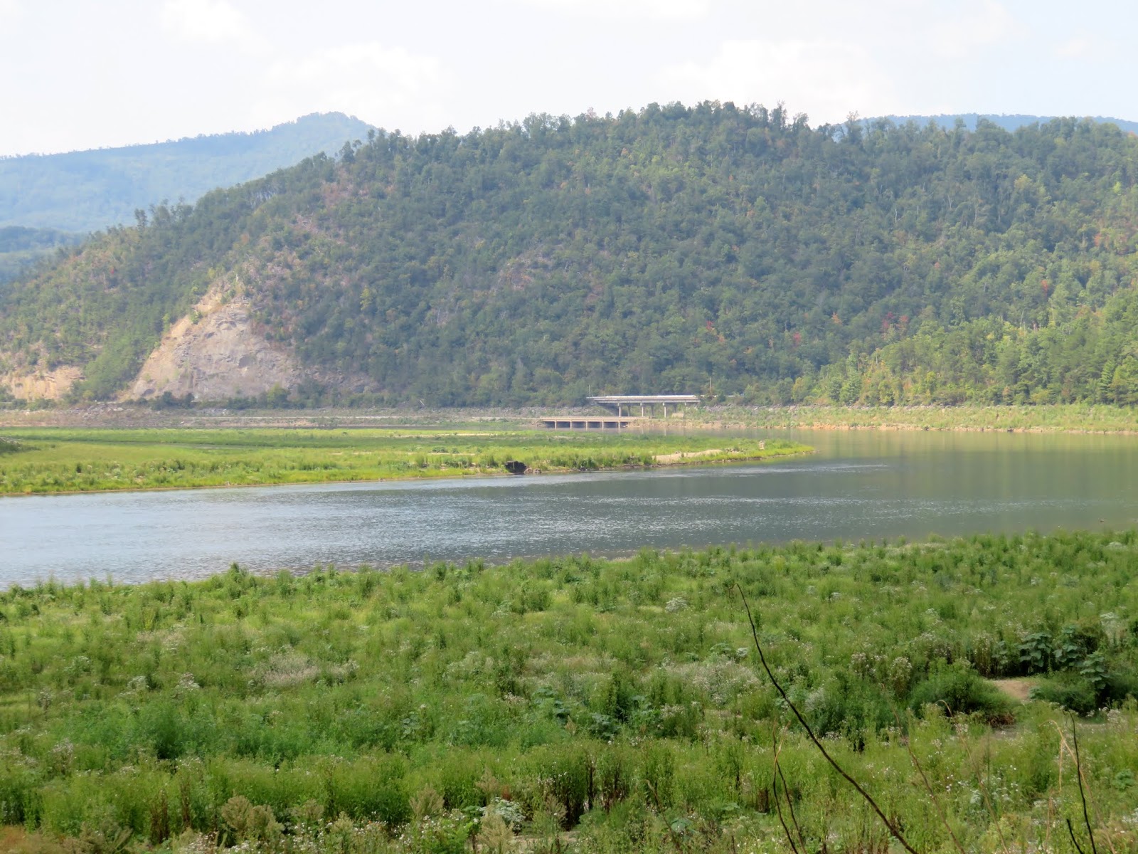
This is
a view from the current Abrams Creek Bridge.
The old US Hwy. 129 bridge is closest to the remaining reservoir but the
pillar bases for a former railroad bridge are exposed as well. One local resident said he used to jump off
the current bridge when he was a teenager…but he had no idea that those other
structures existed.
Here we’re still relatively close to the dam itself so there is still a
reasonably large reservoir evident. The
drawdown was not total but rather only about 20 – 25 feet below normal pool.

In this
photo, old US Highway 129 wanders along the old flood plain into the
mountains. As you can see Mother Nature
isn’t wasting much time reclaiming the ‘new’ landscape.
Tennessee’s
hydroelectric and navigational dam and lock system is huge complex and
interlocking. Actually, Calderwood, Cheoah
and Chilhowee are controlled by the Tennessee Valley Authority’s Fontana Dam, which
is further upriver. In reality, the TVA with Fontana Dam is the primary flow control
facility for the lower Little Tennessee River.

Laurie
took this photo of old Hwy. 129 running across the flood plain with the
remnants of an old bridge in the center.
What
bugged us the most about this whole project is the fact that we had somehow
missed the news about the drawdown and repair project. Seeing it when it was just mud flats would have been much more dramatic. We watch the news every day…and yet this drawdown
was completed in 2015. Rumor has it that
the reservoir may not be refilled to normal levels until 2017.

This is
a photo of that same old Hwy. 129 roadway and bridge shortly after the
drawdown. Mother nature didn’t waste
much time greening everything up, that’s for sure!

Upstream
further away from the dam itself, the Little Tennessee River is pretty much
flowing in its original channel. As you
can see, there was a fairly wide flood plain or valley before the dam was
finished.

This
photo is of a similar area of the river soon after the impoundment was lowered. There was lots of mud and gravel with a bit
of old US 129 visible at the left.
For the
uninitiated, a stretch of US Hwy. 129 through the mountains between Tennessee
and North Carolina is called “The Dragon”or "The Dragon's Tail." It is so named because of its seemingly endless twists and turns through
the mountains. Semi-trucks are not
permitted. Motorcyclists regard this bit
of road as ‘the holy grail’ of cycling…something that every cyclist should do
at least once in their lifetime. It is a
dangerous trip for those who drive too fast or who pass cars along the
route. Deaths and injuries are part of the
scene every year! “The Dragon” begins
where US Hwy. 129 pulls away from the Chilhowee impoundment and heads into the
mountains.
This
view is across the flood plain toward the US Hwy. 129 bridges over Abrams
Creek. This area, as well as the
remaining Chilhowee impoundment/reservoir is off limits to boaters and
explorers until further notice…
FYI…beyond
this relatively small Alcoa Aluminum related operation, the Tennessee Valley
Authority itself operates 29 hydroelectric dams and, in cooperation with the US
Corps of Engineers, is responsible for the maintenance of commercial navigation
all the way upriver to Knoxville Tennessee.
From Knoxville, commercial and pleasure traffic can access Mobile Bay
Alabama as well as such cities as St. Louis, Chicago, Pittsburgh, Nashville,
Minneapolis and New Orleans.


I
borrowed these historic photos from on-line Internet posts. We wondered how many people lived in this valley before it was flooded... While we didn’t see anything this ‘cool’, I
did read that the local sheriff departments ‘recovered’ a number of stolen
vehicles from the lake after it was lowered!
To view
a number of interesting photos that were taken after the 2008 drawdown of the
Chilhowee Impoundment/Reservoir you can go to http://www.knoxviews.com/node/9079.
Just
click on any of these photographs to enlarge them…
Thanks
for stopping by for a visit!
Take Care, Big Daddy Dave
What a fascinating and informative post, Dave! And your photos are lovely! I also love your blog background, it is beautiful! Thank you so much for sharing, and I hope you have a great weekend.
ReplyDeleteHow cool!
ReplyDelete