…continuing with our late summer road trip to Michigan and beyond. Following our roundabout route to Charlevoix Michigan and before we headed south on US Hwy 31, we checked out a couple of sights in this city of about 2,350 residents on the shores of Lake Michigan. At its height in 1970, Charlevoix had a population of about 3,500.

Upon our arrival in Charlevoix, my first stop was at the Chicago and West Michigan Railroad Station. The area around Charlevoix became a popular summer resort beginning in the late 1870s. Responding to the increase in popularity, in the early 1990s the Chicago and West Michigan Railroad extended its line north to Petoskey Michigan. The first trains arrived in Charlevoix in June of 1892 soon after the depot was built.
The
Chicago and West Michigan Railroad merged with 2 other railroads in 1900,
creating the Pere Marquette Railroad.
That railroad promoted Charlevoix and other northern Michigan towns as
summer destinations, with an increasing number of trains arriving at
Charlevoix. At that time there were 2
depots in town and an interurban two-car train ran between the north and south
stations up to 7 times a day.


The first photo as shown above shows the Chicago Avenue Depot in Charlevoix as it appeared in the early part of the 1900s. The second photo is of the old railroad bridge which allowed for visitors and local residents easy and safe access to the beach on Lake Charlevoix.
A
high level of passenger service to Charlevoix continued through World War II,
but the increases in automobile usage in the late 1940s and 1950s cut into
railroad revenues. The Pere Marquette
Railroad merged into the Chesapeake and Ohio Railway in 1947 and service to the
city gradually declined with the last passenger train arriving on September 1,
1962.
In
the 1980s the Charlevoix Yacht Club was based in the old depot. In 1992, the Charlevoix Railroad Station was
donated to the Charlevoix Historical Society and that organization restored the
building. Currently, it serves as a
venue for Historical Society events and programs. It is also available for rental for special occasions
such as weddings, family gatherings, etc.

The homes or ‘cottages’ shown above are right next to the old railroad depot and they still use that passageway under the rail bed to access the beach. The advantage of having homes facing Lake Charlevoix vs. Lake Michigan is that they are sheltered from the storms on the big lake, especially in the winter. Also, boats on Lake Charlevoix can directly access Lake Michigan.
European-American
fishermen initially settled the area, beginning ca. 1852. The Homestead Act of 1862 brought many Civil
War veterans and speculators to Northern Michigan. They were able to purchase 160-acre tracts of
land for $1.25 an acre.


By the
early 1900s, Charlevoix was also a popular stop for many Great Lakes passenger
liners. Pictured above are 2 of the
several vessels that used the town and its harbor as a port of call. The “Milwaukee Clipper” was built in 1904,
was 361 feet in length and originally could accommodate 350 passengers moving
along at 18 knots. The steamer, “South
American” was completed in 1914 for the Chicago, Duluth and Georgian Bay
Transit Company. She was 314 feet long
and was equipped with 3 coal-burning Scotch marine boilers. In 1967, the “South American” was diverted
from her usual schedule to offer trips to the 1967 World’s Fair in Montreal,
Quebec, Canada. At the end of that
season, she was retired from service.


The
photos as shown above show the Beaver Island Ferry, the "Emerald Isle", departing from Charlevoix
via the Pine River channel on its way to its namesake, Beaver Island Michigan.
Shortly
after the founding of Charlevoix in the 1850s. the residents of Charlevoix
entered into a short-live conflict with Jesse Strang, the leader and namesake
of the Strangite Mormons…also the self-proclaimed “King” of Beaver Island. Relations between the townsfolk and the
Stangites was often tense. In 1853, a
gunfight broke out over a man that the townspeople refused to hand over to jury
duty on the island. This gunfight was
known as “The Battle of Pine River”.
Jesse Strang himself was assassinated on June 20, 1856. For more information about Jesse Strang and
his self-proclaimed ‘kingdom’, just go to https://en.wikipedia.org/wiki/James_Strang.
Beaver
Island is the largest island in Lake Michigan in the state of Michigan. At almost 56 square miles, it is the largest
of the 14 islands that comprise the Beaver Island archipelago. It lies about 32 miles across Lake Michigan
from Charlevoix and it has a permanent population of about 650 residents. From May until mid-December the Beaver Island
Boat Company provides service to the island…with reduced service from October
onwards. Air Service via a small local
carrier is also available. Today the
island is a tourist destination…
Why is the ferry
boat shown above named the “Emerald Isle”? Most of the residents of Beaver Island are of
Irish descent. A second ferry us by the
Beaver Island Boat Company is the “The Beaver Islander”. To learn about the ferry schedule, go to https://www.bibco.com/.


Knowing that the phrase “Happy Wife, Happy Life” is factual, I had researched a bit to find places of interest for Laurie along the route of our road trip. One necessity was a nice shop featuring high quality artistic works and imaginative crafts. The Bier Art Gallery and Pottery Studio is located about 6 miles south of Charlevoix on US Hwy 31. The gallery is housed in an old school house. Not only does it feature a great view of Lake Michigan from the upper level but it also offers pottery, sculpture, glass art, metal works, mixed media, and creations from wood, plus an assortment of jewelry to the discerning shopper or collector.

Originally
serving the village of Norwood, the turn of the century Hilton schoolhouse, now
converted into an art gallery and retail operation, served a town that featured
a dock to serve the lumber industry as well as sawmills, a store, boarding
houses, a post office and a hotel named “The Eagle House”.

Laurie has a real love for horses so these small metal sculptures of a mare and her foal found a new home in East Tennessee. Win for Laurie and extra ‘points’ for yours truly.
The early
1900s schoolhouse is a great setting for the arts. Over 60 regional and national artists
contribute to the gallery, many exclusively.
The offerings are both diverse and unique. To learn more about the Bier Gallery and
Pottery Studio, just go to http://www.biergallery.com/.

Continuing south along US Hwy 31, we came to the city of Traverse City Michigan with its beaches and safe harbors on Grand Traverse Bay. The bay is 32 miles long, 10 miles wide and up to 620 feet deep in spots. It is formed by the Leelanau Peninsula and it is further divided into 2 east and west arms by the Old Mission Peninsula.
Traverse
City is the county seat of Grand Traverse County Michigan and it is the largest
city in the 21 county Northern Michigan region.
While the city itself has a population of only 15,700, it is the hub of
the Traverse City micropolitan area which has about 153,500 resident.
The city
is well-known as a center of cherry production, especially the tart
variety. Traverse City hosts the
National Cherry Festival…which attracts about 500,000 visitors each year. With 9 wineries on the Old Mission Peninsula
and 21 more on the Leelanau Peninsula, the area is also known as a center of
wine production in the Midwest.

Upon the arrival of European colonists, they discovered the Grand Traverse Bay. It earned its name from 18th century French voyageurs who made ‘la grande traverse’, or ‘the long crossing’ across the mouth of the bay. Originally owned by the French, it became part of Great Britain’s North American possessions as a portion of the province of Quebec. After 1776, the area became an American possession. The first permanent settlement in the area was on the Old Mission peninsula in 1839.
Given the
bay itself as well as adjacent Lake Michigan, the Traverse City area is a huge
draw for water sports and activities of all types. Beyond water related attractions, Sleeping
Bear Dunes National Seashore, (https://www.nps.gov/slbe/index.htm),
is close by, the Interlochen Center for the Arts is world famous, (https://www.interlochen.org/), and there
even are a couple of casinos operated by Native Americans. (https://www.leelanausandscasino.com/ and https://www.turtlecreekcasino.com/)
Then
there is the possibility for a cruise on a tall ship. There are 3 tall ships based near Traverse
City, two of them shown above. The schooner “Manitou” offers
passage to the public. This replica of a
19th century ‘coaster’ can accommodate 24 overnight guests and up to
59 passengers for day excursions. To
learn more, go to https://tallshipsailing.com/. Other tall ships in the area include the
schooner “Madeline” and a replica of the sloop “Welcome”, an 18th
century British warship.
Over the
years Charlevoix has been home to quite a mix of personalities. Former comedian and Presidential candidate
Pat Paulson lived here. So with famous
hockey great Gordy Howe and well as liberal activist film maker, Michael
Moore. The latest well-known residents
are Pete Buttigieg, the U.S. Secretary of Transportation, and his husband,
Chasten.


Leland Michigan is my last stop for this portion of my narrative and photo journal from our late summer 2022 road trip. This census-designated place has a population of about 410 residents. The village is built on the site of one of the oldest and largest Ottawa (Native American) villages on the Leelanau Peninsula. Where the Leland (aka Carp) River flows into Lake Michigan, there was a natural fish ladder and it was traditional Native American fishing grounds. The settlement was called “Mishi-me-go-bing”, meaning “the place where canoes run up into the river to land, because they have no harbor”.
As early
as 1880, commercial fishermen were sailing out of the harbor to catch trout and
whitefish, building wooden shacks where they processed their catch and
maintained their fleet. Up to 8 powered ‘tugs’
once sailed out of “Fishtown”, as the buildings came to be known.
Note: Laurie and I last visited “Fishtown” more
than 40 years earlier. It has been
preserved and isn’t as ‘primitive’ or ramshackle as we remembered it.
FYI,
Leland is also the port from which tourists and explorers can board a ferry to the
Manitou Islands. Learn more about this
adventure at https://www.nps.gov/slbe/planyourvisit/the-manitou-islands.htm
and at

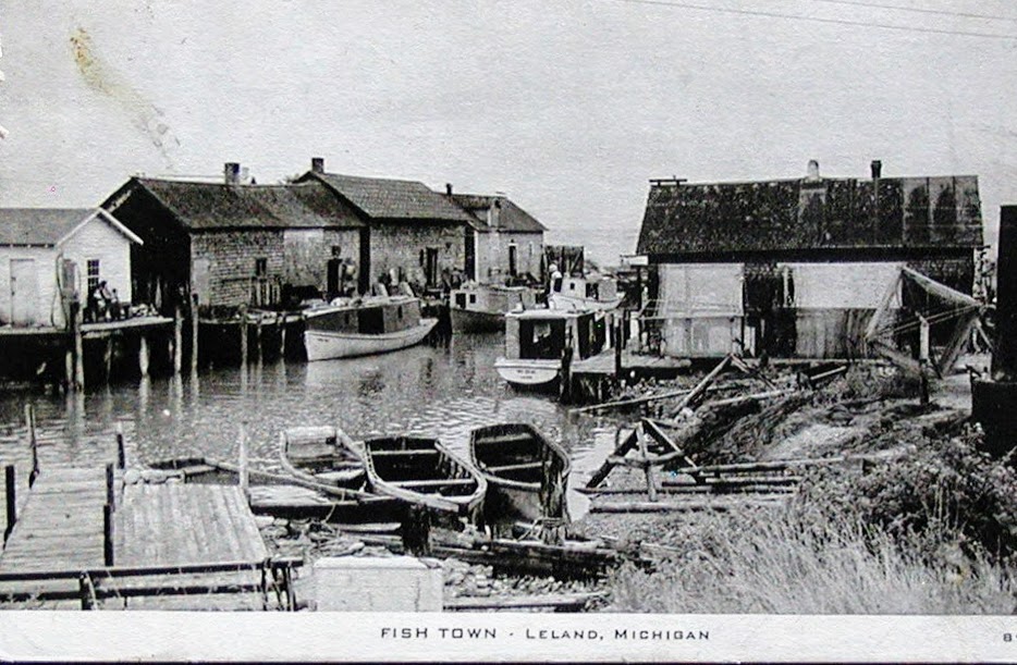
In 1853, Antoine Manseau constructed a dam across the Carp/Leland River. Then he built docks and a sawmill, setting up the village as a ‘wooding station’ for wood burning steam ships. In the early 1900s, fishermen began enclosing their open boats and adding gas engines, increasing the scale of fishing operations. (Old postcard shown above) By 1937, 2 breakwaters were built to further protect the harbor...and the fishing operation continued to grow. However, by the late 1940s, the whitefish and trout populations in Lake Michigan was decimated by sea lampreys. At that point, the area began to rely more heavily on tourism and charter fishing operations.
Starting
in 2019 and intensifying in 2020, many of the historic shanties were regularly inundated
with water due to record high waters in Lake Michigan and increased flow from
the Carp/Leland River. The Fishtown
Preservation Society has raised funds to raise, repair and stabilize the
shanties and to preserved current and future fishing operations.
Today,
the charter fishing business is thriving and 2 fish ‘tugs’, the “Joy” and the “Janice
Sue”, (latter shown above), are owned by the Fishtown Preservation Society. The ‘refreshed’ and revamped riverfront is
lined by a boardwalk and most of the quaint shacks have been converted to tourist
shops. During our visit, we were able to
see salmon running up the Carp/Leland River and leaping up the waterfall to lay
their eggs… To learn more about Leland and “Fishtown”, go to https://mynorth.com/fishtown/.
Just
click on any of the photo to enlarge them…
Thanks
for stopping by for a visit!
Take
Care, Big Daddy Dave
West Michigan Railroad Station looks really beautiful...not a typical railroad station...thought it looked like a small family inn to me. The beach view is really lovely. You and Laurie for sure had a great summer time.
ReplyDeleteInteresting post with many great pics. We visited Leland when up that way in 2018.
ReplyDeleteGreat to see all this area, which I'll never make it to visit myself. Loved seeing the tall ships as well as a couple of "then" and "now" shots. Thank you for great research.
ReplyDelete