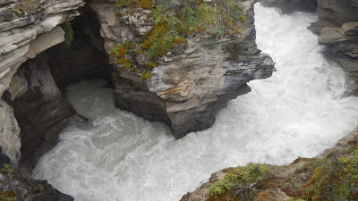
This is the first of many photos we took
of the Athabasca Falls on the upper Athabasca River. This river flows from the Columbia Glacier of
the Columbia Icefield. In Woods Cree,
the word ‘aðapaskāw’ means "where there are plants one after
another". This is probably a reference
to the spotty vegetation along the river.
Athabasca Falls is located about 20 miles
upstream from the town of Jasper. It is
right off the Icefields Parkway. (Turn off Hwy. 93 to Hwy. 93A) Even though the
day was a bit gray, there were plenty of tourists gawking at the falls and
taking photos.
The river 'falls' over a layer of hard
quartzite and through the softer limestone below. As a result, the river has carved a short but
scenic gorge that includes a number of whirlpools and potholes.
I managed to take a couple of photos this
time…although Laurie took most of them as usual… This is a Class 5 waterfall,
with a drop of 80 feet and a width of 60 feet.
Athabasca Falls can be easily and safely photographed
from various walkways, viewing platforms and a bridge, as well as from walking
trails around the falls. Access is from the nearby parking lot, which leads off
Highway 93A, just northeast of the falls.
If you’d like to view a video of the
falls that was made in late August of this year, you can go to http://vimeo.com/76789967.
The video is good…but I found the accompanying music a bit annoying…
The Athabasca River itself flows 765 miles
before draining into the Peace-Athabasca Delta near Lake Athabasca south of
Fort Chipewyan. From there, its waters
flow north as Rivière des Rochers, which joins the Peace River to form the
Slave River. In turn the Slave River empties
into Great Slave Lake and that lake discharges its waters through the Mackenzie
River system into the Arctic Ocean.
The Athabasca River was designated a ‘Canadian
Heritage River’ for its importance to the fur trade and its relationship to the
construction of railways and roads opening up the Canadian West…as well as for
its natural beauty.
North of Athabasca Falls, I decided to
follow Highway 93A instead of Highway 93, which is the main road… Hwy. 93A
stays closer the mountains to the west and it offered a couple of side trips
that couldn’t be accessed from the main road.
Highway 93A starts right at Athabasca Falls…just 20 miles south of
Jasper Alberta Canada.
We drove up the Mt. Edith Cavell Road,
taking occasional photos. That road
stretches quite a distance up toward the peak of Mt. Edith Cavell. (The peak is
11,033 feet high) The mountain was named in 1916 for Edith Cavell, an English
nurse who was executed by the Germans during World War I for having helped
allied soldiers escape from occupied Belgium to the Netherlands.
At the parking lot at the end of the
road, Laurie took this photo of a friendly Mountain Jay who was looking for a
handout… From the parking lot, one can hike up the mountain to Cavell Meadows
and from there the Angel Glacier can be seen overhanging the valley. At this altitude, we opted out of the 4.8
mile round trip hike which involves another quarter mile increase in altitude.
The Gray Jay known as the Canada Jay or
Whiskey Jack, is a member of the crow and jay family. The Gray Jay is a native bird found ranging from
northern Alaska east to Newfoundland and Labrador and south to northern
California, Idaho, Utah, east-central Arizona, north-central New Mexico,
central Colorado, and southwestern South Dakota. These birds cache thousands of food items
every day during the summer for use the following winter.
This is Cavell Lake… It’s fed by the
glacier and it drains into the Astoria River, which in turn feeds into the
Athabasca River.
We also drove on up another road that led
to the Marmot Basin Ski area. Laurie
took this photo from along the road… This ski area is only 20 minutes south of
Jasper. FYI…for those who actually enjoy
cold weather and like to ski, Marmot Basin operates 86 named runs on 3,000
vertical feet of drop, and it has a lift capacity of close to 12,000 skiers per
hour on eight lifts.
I can tell you that nothing at all is
happening at the ski area in the summer!
We didn’t even glimpse any marmots so I ‘borrowed’ a photo of one from
the Internet. Bummer! We love watching marmots. In the summer time, they are very busy
critters indeed... To learn more about marmots, just go to http://en.wikipedia.org/wiki/Marmot.
Next stop on our trip…a 2 night stop in the
town of Jasper Alberta!
Just click on any of the photos to
enlarge them…
Thanks for stopping by for a visit!
Take Care, Big Daddy Dave


Magnificent shots guys. I especially like the gorge.
ReplyDeleteOh how I'd love to see that waterfall. Hubby and I are waterfall---lovers for sure!!!! We have photographed over 600 different waterfalls... Crazy!!!! But --that one is AWESOME... Wow!!!!! I wanna go there!!!!
ReplyDeleteHugs,
Betsy
My Goodness Dave!! The drop looks sooooo steep!!! I don't blame you and Laurie for not going another 1/4 of a mile higher in altitude!
ReplyDeleteThe country is beautiful though.
Blessings to you and Laurie, Catherine
Siimply gorgeous pictures David! I love waterfalls, the scenery is spectacular!
ReplyDelete