The Icefields Parkway is about 140 miles
long and it was completed in 1940. The
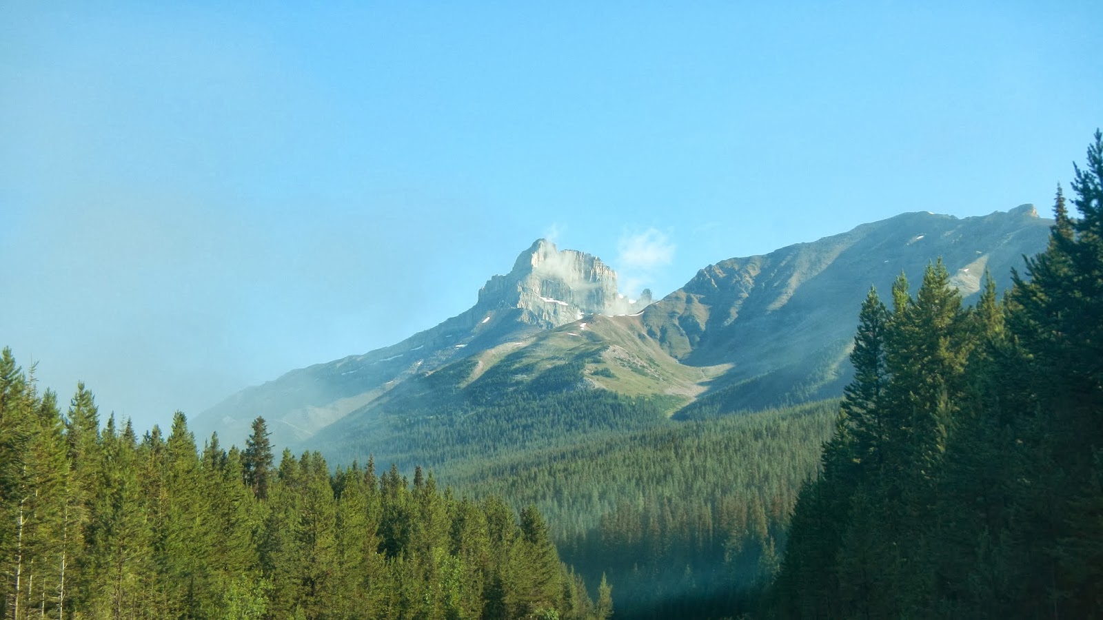
scenery is quite spectacular along the entire route. Mountain peaks border the Parkway on either
side of the road with heights from 8,000 on up to almost 11,000 feet. On the first segment of our drive, Mount Hector,
which was actually on the east side of the road, was the tallest peak at 10,850
feet.

The Parkway parallels the Continental
Divide on the left as one drives north… However, rugged mountains and ridges
border both sides of the road. Icefields
Parkway travels through Banff National Park and Jasper National Park, linking Lake
Louise at its south end with Jasper to the north.

The parkway is fairly busy in July and
August. According to the web, up to
100,000 vehicles use the Parkway during each of those months. The road is mostly two
lanes but there aren’t many steep hills and it’s not at all curvy. We didn’t see any wildlife along the
shoulders of the road but I’m sure they represent an accident hazard. The biggest issues are presented by tourists
parked on the shoulder to take photos or pulling back out into traffic. By our standards, traffic was minimal…

Icefields appear along the Parkway
shortly after you depart Lake Louise.
Before long, you’ve passed the Wapatik, Wapta, Freshfield and Mons
Icefields...all on the west side of the road.
There are also a number of smaller glaciers on both sides of the road.

Several lakes border the Parkway…and
others can be reached via auto not far off the highway. There are at least 8 lakes along the route in
just the first segment of the road.
These include Hector, Peyto, Herbert, Helen, Katherine, Bow, Chephren,
Cirque, Glacier and the Waterfowl lakes.

During one stop, Laurie captured a photo
of the only wildlife that we saw during our drive… It’s a fierce Canadian
Chipmunk!!

FYI… A Canadian national parks permit is
required to travel on the Icefields Parkway…and the law is enforced! The speed limit is 55 miles per hour…which is
good as it allows visitors to take in the views and safely pull off and on the
roadway. The good news is that commercial
trucks are prohibited!

We sure lucked out during the first portion
of our drive. However, the weather did
change as we slowly moved north, taking photos and sightseeing as we went.

All of these glaciers and icefields mean
water…and lots of it. During August of
course, the ice is melting and feeding the streams, rivers and lakes. For part of the drive, we bordered headwaters
of the Bow River. Then we came upon the Howes
River which fed into the North River. All
of the rivers along the first part of our drive flow east into the Saskatchewan
River, and eventually into Hudson Bay.
River valleys along the road are wide and very scenic!

All along the Parkway there are plenty of
sites to have a picnic, lots of hiking trails, places for camping and RV’s, and
of course, a plethora of scenic viewpoints for visitors to pull off the road…

This is ‘The Crossing’. It’s located about a third of the way along
the Parkway heading north to Jasper. It’s
a resort where you can buy gas, grab a snack or a full meal, find a restroom
and spend some money in the gift shop. The Crossing is at the junction of Hwy. 93 (Icefields
Parkway and Hwy. 11, which goes east to Red Deer Alberta. Highway 11 is the only road intersecting
Icefields Parkway for the Parkway’s entire length… For more, go to http://www.thecrossingresort.com/.

This is just one of the many streams
flowing down from the mountains and icefields into the valley where the road is
located…

There weren’t many open meadows like this
along the Parkway. It offered a nice
contrast to the mountains and the forests…

By far the largest of the icefields along
the Parkway is the Columbia Icefield and its associated glaciers. For those of you who like geographical
factoids, the Athabasca River and the North Saskatchewan River originate in the
Columbia Icefield, as do tributary headwaters of the Columbia River. In effect, the icefield is atop a triple Continental
Divide as these rivers eventually flow north to the Arctic Ocean, east to
Hudson Bay, (and then to the North Atlantic Ocean), as well as south and west
to the Pacific Ocean.

What happened to the blue skies and
sunshine? Once again, the Canadian
Rockies demonstrated that the weather can best be described as ‘bi-polar’… You
just never know what it’s going to do next!

The Columbia Icefield lies partly in the
northwestern section of Banff National Park and the southern end of Jasper
National Park. It is about 842 square
miles in area and the ice is 328 to 1,197 feet deep. The Columbia Icefield receives up to 275 inches,
(roughly 23 feet), of snowfall each year.

The Columbia Icefield feeds at least 6
glaciers: Athabasca, Castleguard, Columbia, Dome, Stutfield and Saskatchewan.
FYI… I didn’t know this but an icefield is an area
less than 19,305 square miles They consist of an extensive area of
interconnected valley glaciers from which the higher peaks rise as ‘nunataks’.
Icefields are larger than alpine glaciers, smaller than ice sheets and similar
in area to ice caps. From what I can
determine, as compared to an icefield, a glacier is “a persistent body of dense
ice exceeding a specific surface area which is constantly moving under its own
gravity.

This is about as close as we got to one
of the glaciers. I’m not sure which one
it was…but I believe that it was the Athabasca Glacier. One can go on ice walks on the icefield and
take rides on ‘Brewster Ice Explorers’, vehicles that are specially designed
for glacial travel. Accommodations are available
near the icefield as well. For more
information, go to http://www.explorerockies.com/columbia-icefield/.

This pretty waterfall was right along the
Parkway on the east side of the road… It’s called Tangle Falls. I’ve since learned that these are the upper
falls and, if one is willing and able to hike a bit, there is much more to this
cascade than meets the eye. If you’d
like to see some great photos of this series of waterfalls, go to http://www.northeastwaterfalls.com/waterfall.php?num=1345&p=0.
Also, for some great (truly professional)
scenery photos of the Canadian Rockies, you can click on this link: http://www.pbase.com/deanhueber/canadianrockies.
That’s about it for the first 80% of our
drive north along the Icefields Parkway.
Just click on any of the photos to enlarge them…
Thanks for stopping by and checking out
this chapter of our Canadian Rockies adventure!
Take Care, Big Daddy Dave
We made this drive in winter and it was very pretty, but it's even more so in summer and I'm glad I got to see it via your trip.
ReplyDeleteWow---just awesome, all of it... Makes me want to go there ASAP..... Thanks for sharing all of that beauty.
ReplyDeleteHugs,
Betsy
Dear Dave, The scenery is simply breathtaking!!! It really is so untouched.
ReplyDeleteI especially love the chipmunk though.
Blessings. Catherine