In a
recent posting, we’d photographed a number of historic places and sites in the
area that we hadn’t found during much earlier explorations. Again, all of these sites are listed on the
National Register of Historic Places having been nominated for that document
for reasons ranging from local historic significance, to architecture and even
due to regional or national impact.
I had a
list of places to find, my trusted GPS turned on and my better half to spot and guide me
as we headed out to search for the remaining few historic places that we hadn’t
come across yet…

This
handsome antebellum Greek revival home is located at 3224 Sweetwater-Vonore
Road. It was constructed in 1857 using
brick on a limestone foundation. The
home is best known as the John McCroskey House but it is also referred to as
“Glenloch”, the name given to the home by Mr. McCroskey. In addition to the house, in 1867 John
McCroskey’s will established half acre for a family burial ground…
McCroskey
was the first Sheriff of Monroe County.
He was a slave owner (with 640 acres) and he apparently went against the
rest of his family by supporting the south during the Civil War. After the war, one of his sons, Joshua Philander
Theodore McCroskey and his wife moved west to the eastern part of the Oregon
Territory. They built a home in Oregon
that was remarkably similar to his father’s home in Monroe County Tennessee. JPT and his wife are also credited with
attracting about 1,000 Tennesseans to Oregon Territory…and the area where they
settled is still referred to as the “Tennessee Flats”.

This is
the William H. Griffitts House on Jackson Ferry Road in Loudon County
Tennessee. It was completed in 1854 when
the area was part of Blount County. The
style is referred to as “East Tennessee Vernacular” but it does exhibit some
Federal influences. The home has 9 rooms
and 5 fireplaces…
William
H. Griffitts was born into a Quaker family in 1825. Along with other Quakers in the area, the
Griffitts family actively supported the Underground Railroad movement that
aided fugitive African-American slaves in their attempt to reach freedom in the
northern USA. The house has also been
identified as a ‘station’ along the ‘railroad’.
During the war they also sheltered white Southern men that wanted to
avoid conscription by the Confederacy.
As a
Quaker during the Civil War, Griffitts was a conscientious objector. In lieu of military service he worked in a
salt mine in Kentucky. His wife and
teenage son managed the farm during his absence. After the war, the family allowed former
slaves to live on a portion of their property that (as of 1989) was still known
as Negro Hollow. The property remained
in the Griffitts family for 106 years until 1960.


This is
the Cloyd’s Creek Presbyterian Church…which, appropriately enough…is located on
Cloyd’s Creek Road in Blount County.
This congregation was organized in 1871 and the church was built in
1872. It did replace an earlier log
structure. The frame structure with a
gabled front façade and the wide portico with Doric columns is one of the least
altered churches in the county. The
adjacent cemetery is still in use and pictorially, it adds a bit of history and
meaning to the overall setting…


These
photos show the Calderwood Dam in the mountains along the Tennessee River in
Blount and Monroe counties. It was
completed in 1930 and its one of 4 dams…along with Cheoah, Santeetlah and
Chilhowee…built along the river by Alcoa in the early 1900s to provide
electricity for its smelting operations in Blount County. The dam is named for Alcoa engineer Isaac
Calderwood who supervised much of the company’s early operations along the
river.
This dam
was one of the last to be completed in the Tennessee River watershed before the
Tennessee River Authority took control of the watershed in 1933. These views of the dam were taken from a
viewpoint along US Hwy. 129. This
section of the highway is referred to as “The Dragon” due to its many twists
and turns and it is very popular with motorcyclists. There is a gravel walkway from this viewpoint
that takes the more adventurous closer to the dam for a better view…

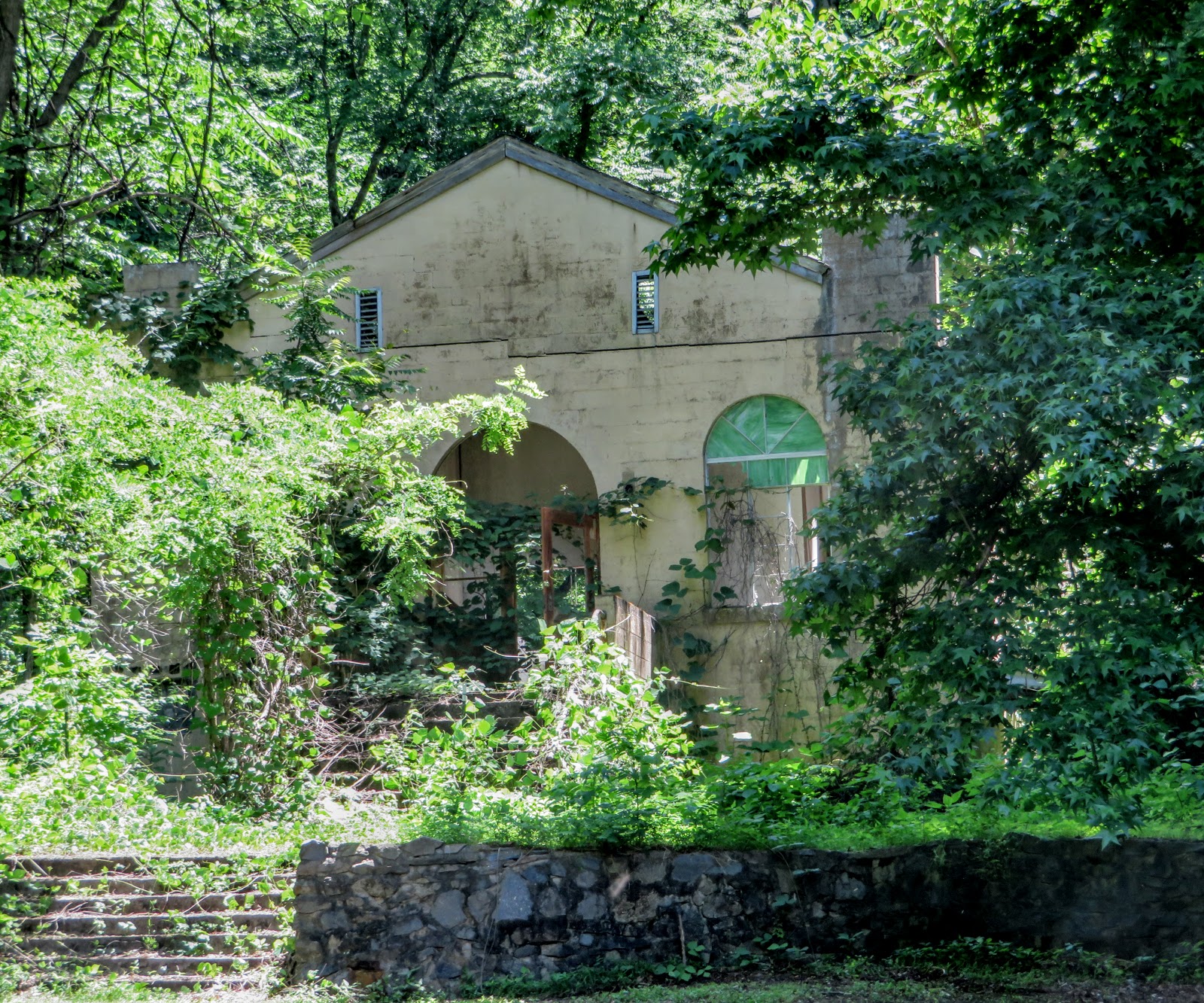
Access is
possible below the dam as well. This service
building is included as part of the historic site. Another gravel walkway leads from behind the
service building to the powerhouse and a view of the dam from the area at its
base…
The
community of Calderwood Tennessee was located downriver just below the service
building. The town was developed in 1912
to house construction crews for Alcoa’s Little Tennessee Projects. The town was originally named “Alcoa” but its
name was changed to “Calderwood” in 1920 when the company reapplied its name to
its primary company town adjacent to Maryville Tennessee. The Calderwood community grew to include a
couple dozen houses, 2 churches, a school and a theater, but when construction
and maintenance crews were no longer needed, the town was abandoned in the 1960s
and its houses were all razed. The area
is accessible to the public and it’s now used as a recreation area.
The structure shown above is the former Calderwood Baptist Church. It was completed in 1954 and it’s slowly becoming part of the surrounding forest.
Another structure that has survived (no photo) is a Quonset hut that
served as a theater and is now used for storage.


These photos are of the Calderwood Methodist Church and cemetery. This church was completed in 1954. Both it and the cemetery are fairly well
maintained. Apparently the church is no
longer in general use… Remaining signs of the town are otherwise limited to
sections of sidewalk, steps which led to homes and a stray fire hydrant or two…


This is
the Clover Hill Mill in Blount County Tennessee. When this mill was added to the National
Register of Historic Places in 1989, it was one of the few early 20th
century mills still in operation in East Tennessee. I could be wrong but when I took this photo,
it didn’t appear to be operational.
The
community of Clover Hill was established in the 1820s and by 1849 the first
gristmill was built. By the 1860s, the
village had its own post office, school, church, distillery and general
store. The town declined after 1906 when
a rail line was completed a few miles north and the population shifted. The old gristmill burned down in 1921 and
this mill was built. FYI, the town was
named “Clover Hill” by Abijah Conger who had a large clover farm and who also
established the post office in his general store.

This
building is a bit unusual in that it’s fairly new...only 67 years old. The War Memorial Building in Lenoir City
Tennessee was constructed in 1951 to honor the veterans of Loudon County. The building has been used as a community
center, a gym, a place to hold graduations, the home for a local theatre group
and as home for American Legion Post #70.
For information
regarding the Last Call Theatre Company and their latest production, go to https://www.facebook.com/lastcalltheatrecompany/.
For information
about American Legion Post #70, go to https://www.facebook.com/American-Legion-Post-70-Lenoir-City-247936545567935/.

A number
of memorial plaques are mounted on the front of the War Memorial Building. The names of military
members killed in action in WWI, WWII, the Korean War and the Vietnam War are listed on these 3 plaques...

This photo is of the memorial plaque for Sergeant Mitchell W. Stout who was
posthumously awarded the Congressional Medal of Honor for his valor in action
during the Vietnam War. He died
shielding his men from a hand grenade that had been thrown into their artillery
bunker. The gym at Fort Bliss is named
in his honor as is the I-75 Bridge across the Tennessee River at Loudon Tennessee.
That’s it
for now… Just click on any of the photos to enlarge them.
Thanks
for stopping by for a visit!
Take
Care, Big Daddy Dave
I've always enjoyed that view of Calderwood from above.
ReplyDelete