Showing posts with label DeVeaux School. Show all posts

Friday, September 23, 2022

My Hometown – History and More (1)

After about 12 years, Laurie and I made our way back to my hometown, Jackson Michigan.  While I wasn’t born here, I lived here when I was a baby up through the 3rd grade…returning in the 4th grade and then through the 9th grade.  After that I was off to DeVeaux School, an Episcopalian boarding and day student school located in Niagara Falls New York.  I returned home for the holidays and summers through my senior year before heading up the road to East Lansing Michigan and Michigan State University.  Right off hand, I can recall 9 different homes where my family lived in Jackson. 

While in the area, Laurie and I spent quite a bit of time exploring Jackson and other nearby locations that had some significance in my life or which have some historical significance.  We decided to start in the downtown area.

The First Baptist Church has had a presence in Jackson for over 180 years.  The church members gathered in a variety of locations for 35 years, but in 1869 construction began on this Romanesque Revival-style building.  A lack of funds delayed completion until a member of the building committee agreed to erect the walls for free if the materials needed could be supplied.  A donation in 1871 by 4 members of the congregation insured that the church would be completed.  It was dedicated in March of 1872.

St. Paul’s Episcopal Church was my family’s church in Jackson.  My stepfather was active in the church and his memorial services were held here.  It was the Reverend Canon Frederick W. Brownell who helped my mother gain my admission to DeVeaux School where I was prepared for college.  Without Reverend Brownell’s assistance, my mother wouldn’t have been able to afford this educational opportunity. 

My Dad, S/Sgt. Ronald Allen Myers, with 7 others who gave their lives for their country, is memorialized in one of the St. Paul's stained glass windows.

In 1839 Reverend Charles Fox arrived in the fledgling town that was emerging from a wilderness swamp.  He first organized the Episcopal Church in Jackson.  Located at 309 South Jackson Street, St. Paul’s is one of the oldest Episcopalian parishes in the state.  A 100 seat wooden church was consecrated at this location in October of 1840.

The cornerstone for this new $6,100 Romanesque Revival church was laid in August of 1850 and the church was consecrated in January of 1853.  The church is listed on Michigan’s State Register of Historic places.  For many years, beginning in 1958, the church’s Women’s Club conducted a town hall series as a church fundraiser.  Speakers included First Lady Eleanor Roosevelt, author Erma Bombeck and actor Vincent Price.  This series was a major social event until it ended in 1980.


As we initiated our exploration of downtown Jackson, we discovered that the city was about to initiate a weekend of artistic expression and celebration.  This was the fourth iteration of “Bright Walls”, a public art and mural festival founded and run by volunteer members of the Jackson Young Professionals.

More examples of these artistic wall murals will follow in this post as well as the next one…

As usual I’d pulled together a list of historic places to find, photograph and write about.  This is the oldest building in Jackson.  The Stone Post Office, also known as the Blackwell Building is located at the rear of a business near the center of town.  It was listed on the National Register of Historic Places in 1972.

The first post office in Jackson was located in the log home of the village’s first postmaster.  But, in 1839, Joseph G.R. Blackwell, a wealthy businessman, constructed this stone structure to house his general store, which at that time faced the town’s small public square.  Subsequently, the building was used as the city’s post office…and it continued to serve as such until 1894.  Other buildings were built around this structure and since then, it has mostly been used as a warehouse for a series of businesses. 

The First Congregational Church is another historic church in downtown Jackson.  Currently, this church is home to the First Congregational Church, United Church of Christ of Jackson.  Originally, Congregationalists and Presbyterians formed unified churches on the western frontier.  After a series of splits and other church structures, in 1858 the church members bought 2 lots where they would build their new church.  It was dedicated in 1860.  However the congregation continued to grow and by 1871, it was evident that they needed a meeting hall and Sunday school rooms.  So the entire building was raised by 8 feet and a lower section was built underneath the original structure.  Then in 1895, a new entryway was added to the building.


The Bright Walls Festival featured local artists as well as artists from across the globe.  Over 70 murals have been created in downtown Jackson.  This community project speaks well for the city.  In addition to the artists and musicians, sponsors, building owners, other community organizations and of course, volunteers.  More information on that building in the second photo will follow...

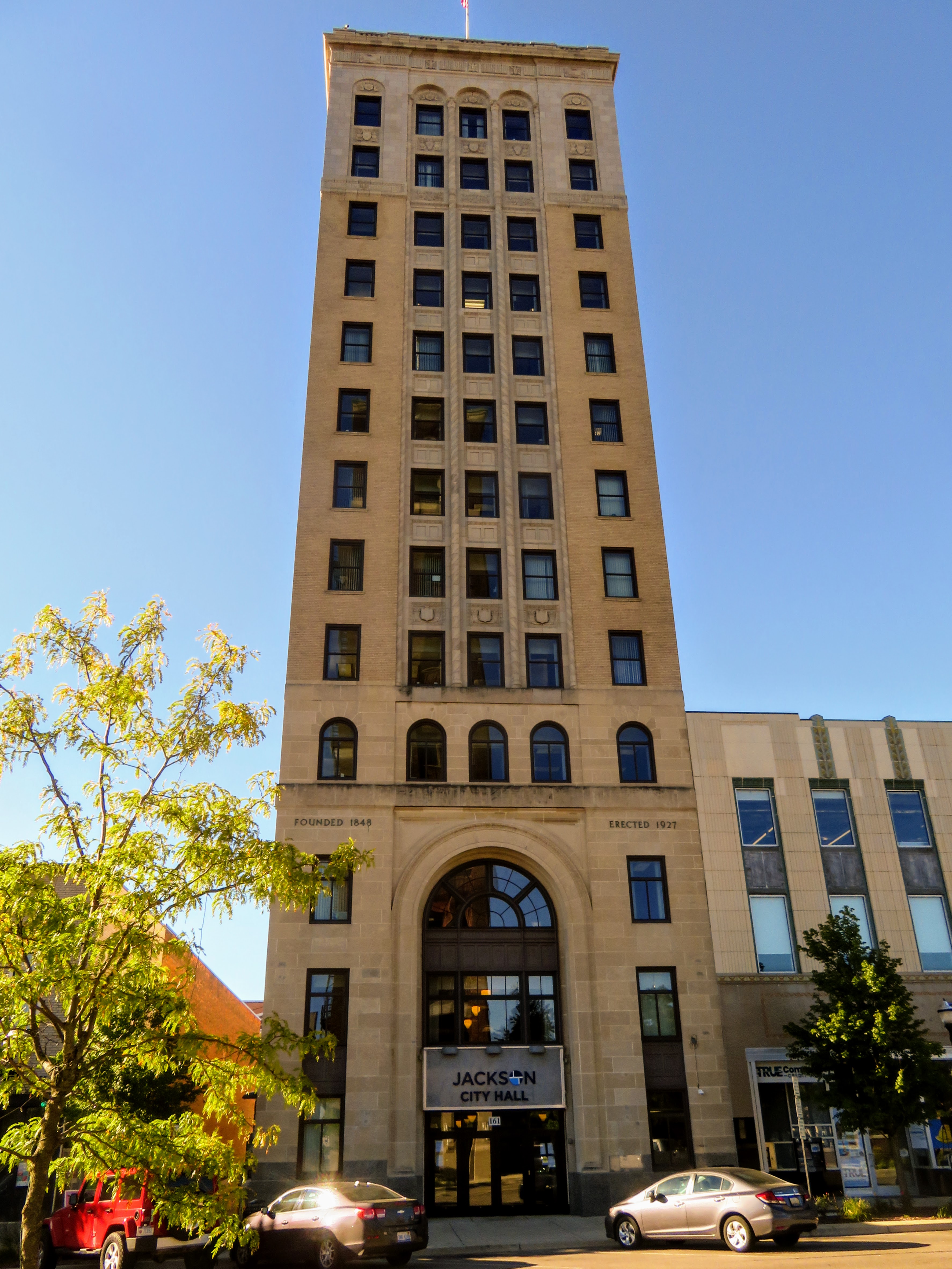
This is Jackson’s City Hall at 161 West Michigan Avenue.  This 183 foot tall building was built in 1927 to house both the Jackson City Bank and some offices for the city.  Today, it’s fully occupied by city employees.  In 2005, the city invested $10 million to renovate the building. 

Note: There are 3 buildings in Jackson that are taller than the City Hall.  Two of the others are also historic but I didn’t take picture of them.  The tallest building in town is the County Tower Building at 230 feet high.

A little history… Founded in 1829, Jackson was named after President Andrew Jackson.  The town was first called Jacksonopolis and then Jacksonburgh.  At the beginning of the 1900s, it became an early automotive manufacturing center that attracted southerners and immigrants to the city’s many factories.  The current name was officially changed to Jackson in 1838.

How important was Jackson in the early part of the 20th Century?  It was the hub for 8 different railroad lines and it was home to no less than 21 different automobile manufacturers.  In 1920, Jackson was the 8th largest city in Michigan…today it’s the 33rd.  In 1910 the city’s population was 31,433.  In 1930 it was 55,187.  In 1950 it was 51,088.  When I headed off to college in 1961, the population was at roughly 50,000.  Today Jackson is home to only 31,309 residents…a few less than back in 1910.  The auto industry moved to Flint and Detroit and the railroads lost their impact as motor vehicles became more relevant.  Yet another rust belt town that is trying to make a comeback.

Remember the building with the flowers on one side that I'd mentioned above? It is the Morris building, also known as the Ismon building as well as the Carter-Sherman building.  This structure was built at the corner of Michigan Avenue and Jackson Street way back in 1853.  During the Civil War a Union Army lawyer practiced law here and he enlisted men from around the county for military service.  Mr. Ismon was a founding member of the Jackson County Bank in 1872.  Over the years, the building has been home to a dry goods store, a barber shop, a men’s haberdashery, a barber shop, then a shoe store and a jewelers.

The photo from 1938 as shown above is more or less how I remembered the Morris building  from the early 1950s into the 1960s.  The on-going construction shown in the photo was for the new Woolworth Store going in next door.  The ground floor of the Morris building housed a Rexall Drug Store with the second and third floors serving as the home…at the time…as Jackson’s only Asian restaurant.  I must admit that we never ate at the Fairy Garden Restaurant…as our Sunday favorite was the now long gone Regent Cafe.  Fairy Garden was popular though.  Ralph and Fong Hoy Lew, his wife, operated this restaurant until 1950 when their son William took it over.  William Lum and his family ran the restaurant until 1973.


Downtown Jackson looked pretty darn good during our visit...lots of flowers and greenery!  I did note that the massive former Consumers Power Building with its appliance sales store had been demolished and the downtown park area expanded.  My stepfather was a salesman there.

A portion of this park has been recognized for its connections to the Underground Railroad.  Bucky Harris Park was added to the National Park Service’s National Underground Railroad Network to Freedom.  Michigan’s first anti-slavery newspaper, The American Freeman, and 3 other anti-slavery newspapers were all founded in commercial buildings around this center of the city. 

Note: I was puzzled… Who the heck was Bucky Harris?  It took some digging but it turns out that he was a local businessman.  Charles “Bucky” Harris owned the Harris Building next to the park.  That building is now called the Blake Building and it is the 2nd tallest building in Jackson at 198 feet in height.

I decided to end this post with something sweet.  John O. Gilbert and his wife Mary had operated a bakery and confectionary factory in Findlay Ohio, starting in 1893.  They outgrew their city and their building and they decided to move to the much larger city of Jackson Michigan.  They opened 2 retail stores in Jackson and the reputation of Gilbert Chocolates grew to the point where they had to build a large two-story factory in 1913.  John continued operations until about 1960 and then the company was sold and operated by two successive owners. 

The good news is that 2 stores are again operating in Jackson.  Even more importantly, the business has maintained its reputation as offering the finest gourmet chocolates in Michigan.  The store and factory shown above opened in 2016 and it’s located in downtown Jackson at 233 North Jackson Street…not far from the location of the original stores and factory.  Gilbert’s Chocolates can be purchased.  See: https://www.gilbertchocolates.com/.

Just click on any of the photos to enlarge them…

Thanks for stopping by for a visit!

Take Care, Big Daddy Dave

Friday, December 6, 2019

20th Century Maps and Travel


Back in the late 1950s and into the early 1960s, I’d attended DeVeaux School in Niagara Falls New York.  In recent weeks, Gary, one of my college prep school classmates, tweaked my memory and thought process with photos of some of his antique maps and other collectibles.

I started considering some of the paper ephemera type collectibles that I had been given or purchased over the years…and I decided to take a good look at what I had stored away.

In this first post about my ‘discoveries’, I focused on maps and travel related materials ranging from the 1930s up to the early 1960s.  How times have changed!


Based on the population provided for St. Louis in its towns and cities listings, this road map of Missouri was published sometime in the late 1930s.  There sure were a lot of ‘improved’, graded and dirt roads on the map!  Travel had to be a real adventure. 

FYI, in 1930 the census for St. Louis was 821,960.  Today it’s estimated to have declined to 302,838!  It isn’t even in the top 50 largest cities…

Apparently Conoco was a force in the travel industry back in the mid-1900s.  Founded in Ogden Utah in 1875, it changed ownership and merged with other oil companies several times.  But in 1929, it was acquired by Marland Oil Company…later the Continental Oil Company.  In 1930, it was given its red triangle trademark which remained in use until 1970.


In the late 1930’s Conoco debuted a couple of clever marketing efforts.  One was “Gentlemen Prefer Bronze”, which while being a bit sexist, was an attention getter back in the day.  FYI, “Bronze” was the company’s latest gasoline brand.

The other marketing effort involved the introduction of the Conoco Travel Bureau...as pictured above.  It provided drivers free travel information and the maps were marked with the locations of Conoco Service Stations.  They also produced “Touraides”, basically a personal travel plan or ‘Triptik’ for vacationers.  Of course AAA had introduced travel planning and the ‘Triptik’ much earlier.  Conoco advertised that every one of their service stations was a branch of their Travel Bureau.  They even offered customers a ‘Conoco Passport’ that supposedly provided for special services at their service stations.


The second item on my maps and travel list is a map of the “Puget Sound Country” featuring portions of Western Washington State and Oregon in the USA and British Columbia in Canada.  This map, dated 1936, was a marketing piece published by the Black Ball Line, perhaps better known as the Puget Sound Navigation Company based in Seattle Washington.

The west coast version of the company was founded in 1898.  In addition to Puget Sound, the company operated steamboats and ferries in the Georgia Strait in British Columbia.  The PSNC actually had a virtual monopoly on cross-sound traffic in the 1930s, even competing with the Canadian Pacific Railway’s steamships on several routes.


The picture above depicts the PSNC’s Puget Sound Fleet at the time the map was printed.  They had 22 ferry boats of greatly varying sizes in operation.  In those days, with few bridges between the mainland and the Olympic Peninsula or the islands in Puget Sound, a lot of boats were needed for a lot of routes.  After looking at the old map and reading about routes, there were at least 17 routes.


Looking back at the previous full page photo of the ferry boats in operation in Washington State in the mid-1930s, I couldn’t help but notice the first boat at the upper left hand corner.  So, I went to Wikipedia and borrowed a bigger photo as shown above.

The MV Kalakala was built on the hull of the former MV Peralta that had been destroyed via an arson fire in San Francisco.  The decision was made to make this ‘new’ ferry boat unlike any others.  That eye-catching streamlined superstructure was complemented by art deco styling and upscale amenities.  The Kalakala was put into service in 1935 and she was an immediate celebrity.

Note: The Admiral Riverboat that was based in St. Louis Missouri was also built on the hull of a previous vessel... Completed in 1940, it was built with a similar 'streamlined' look.

When she was first launched the MV Kalakala was the 2nd most photographed man made thing in the world, after only the Eiffel Tower. (Note: The Golden Gate Bridge was completed a year later) Even as late as 1962 when Seattle held its World’s Fair, visitors ranked the Kalakala second among all area attractions, with the Space Needle being first.  This ferry was in service until 1967…then sadly served as a cannery for both fish and shrimp in Alaska…before finally being scrapped in 2015.


While the map itself is too large for me to copy, I did copy this page showing major tourist attractions in the areas covered by the map.  Laurie and I have spent many happy and scenic vacations in Washington, Oregon and British Columbia and we’ve taken the only remaining ‘descendent’ Black Ball ferry route that remains, the MV Coho from Port Angeles Washington to Victoria British Columbia.  Website: https://www.cohoferry.com/.

The old Puget Sound Navigation Company was purchased by the State of Washington in 1951.  The Washington Ferries Division of the Washington Department of Transportation now operates most of the ferry routes that PSNC used to operate.  Washington Ferries operates 23 ferries and carries over 23,000,000 passengers each year.  Measured by vehicles carried, it is the second large such operation in the world.  Only Turkey’s Istanbul Fast Ferries, Inc. with 87 ferries is larger.

To learn more about the long and convoluted history of the Blackball Line/Puget Sound Navigation Company, which actually started on the East Coast of the USA in the trans-Atlantic trade, you can just go to https://www.cohoferry.com/img/pages/Black%20Ball%20Line%20History.pdf.


This map of Chicago is another old one that I have from the 1930s.  Again the map itself is too large for me to copy.  It does include some interesting facts.  The population of the city as per the 1930 census was 3,599,997.  By 2010 it was down by about 900,000 residents to 2,695,598.  With no expressways to handle the traffic, I can’t even imagine what a challenge getting across town must have been like!

As you will note, the map was published by the Standard Oil Company of Indiana…which in 1985 became AMOCO…and is now BP/AMOCO.  Standard Oil Company of Indiana was a spin off from John D. Rockefeller’s original Standard Oil Company.  That company was judged to be a monopoly and was broken up in 1911, creating a number of separate entities including Standard Oil of Indiana. (We always used to stop at Standard Filling Stations when I was growing up)


This is one section of the ‘newest’ of my collectible road maps.  It was printed in 1961 after the Illinois Tollway System was partially completed.  I-94 wasn’t completed on the south side of town, the East-West Tollway ended just west of Aurora and part of the Edens Expressway wasn’t finished yet either.  58 years ago, automobile tolls for the central portion of the Tollway were 30 cents at the main toll plazas.  Speed limits were 65 mph for cars…not that anyone ever drove or drives that slowly in Chicago. (1961 was the first year I drove to Chicago...from Jackson Michigan to make a delivery to a business in the loop.  It was an adventure!)

Note: On June 29, 1956, President Dwight D. Eisenhower signed the Federal-Aid Highway Act.  That bill created a 41,000-mile “National System of Interstate and Defense Highways”, the Interstate system that we know so well today.  What a major impact on travel and life in America!


Back to the Pacific Northwest!  This time I’m featuring a travel book or guide published by the Union Pacific Railroad in 1936 or 1937.  “Pacific Northwest and Alaska” focused on the destinations that travelers might be interested in while subtly promoting rail travel especially from Chicago and the Midwest but also from Southern California.

Included in the attractions listed in the travel book is the Ski Resort in Sun Valley Idaho.  It’s the only listing outside of Washington, Oregon, Alaska and British Columbia.  The reason it was included seems obvious if you do a little research.  In the early 1930s, the Chairman of the Union Pacific, Averell Harriman decided to develop a destination winter resort in the western USA in order to increase ridership on UP passenger trains.  Hence, the Sun Valley Lodge opened in 1936 and it was a big hit.  Under new ownership, it’s still in business.

FYI, Averell Harriman was later Governor of New York State, ambassador to the Soviet Union, advisor and confidant to Presidents and a 2-time candidate for the Democratic nomination for President.  When he passed on in the mid-1980s, his estate was still valued at about $140 million.


At least this map…included toward the back of the UP Travel ‘Guide’…was small enough for me to copy.  It shows the Union Pacific Railroad network as well as related rail connections.  Passenger service included Chicago, Kansas City, Omaha, Denver, Salt Lake City and most other major cities west of Salt Lake City.


This picture shows the passenger train featured in the UP book.  The “City of Portland” was operated by the Union Pacific Railroad and the Chicago and Northwestern Railway between Chicago Illinois and Portland Oregon.  Service began in June of 1935 using an M-10001 streamliner.  That train was replaced by the one shown above, which I think is an M-10002 diesel-electric streamliner that had more power and could pull more cars.  It was an ‘articulated trainset’ and the last ‘turret cab’ streamliner.  In appearance, it looks almost like the M-10001…

As for the original, the M-10001, which was completed in 1934, it was the first streamliner with sleeping cars.  Beginning in 1936, it made the trip from Chicago to Portland in 39 hours and 45 minutes.  Before that the fastest train took 59 hours and 20 minutes.  In October 1934, the M-10001 set an as-yet unbroken record of 57 hours from coast to coast/Los Angeles to New York City.


This Rand McNally Pocket Map of Tennessee is the last item I’ve included in this posting.  It was also printed and published in 1931. One side of the map is the road map…and as a sign of those times, the other side shows all the rail lines in the state.  Love the steam locomotive and the classic automobiles...

Of course in 1931 there were many roads that weren’t paved, Oak Ridge Tennessee didn’t exist yet and the ‘highway’ over the Smoky Mountains from Elkmont and Gatlinburg Tennessee to Cherokee North Carolina was still a dirt road!  In addition, there was no Kentucky Lake nor any other TVA dam or reservoir in existence when this map was printed…mainly because the Tennessee Valley Authority wasn’t approved by Congress and signed off on by President Roosevelt until 1933.


The two large maps in the Pocket Map booklet are too big to copy and include in this post but here are the city maps of Nashville, Memphis, Knoxville and Jackson Tennessee.  What a change in these city maps from then to now!  Of course, the increase in the number of cars and trucks in use and the population growth has had a major impact.
 
In 1930 Nashville had 153,866 residents and its estimated population today is 692,587.  Memphis: 253,143 vs. 650,618.  Knoxville: 105,802 vs. 187,500.  Jackson: 22,172 vs. 66,903.  Keep in mind that these numbers are just for the cities themselves and doesn’t include the suburban areas around them… The State of Tennessee had 2,616,556 residents in 1930.  The estimated population as of 2018 is 6,895,418!


Old Coca Cola ads are always interesting.  This one depicts a trail ride down the Bright Angel Trail into the Grand Canyon…and lays claim to 9,000,000 Cokes consumed every day.  Today that number would be hovering around 1,700,000,000 per day!

Regarding the second large map contained in this Pocket Map booklet.  It lists a total of 22 different railroads operating in Tennessee!  Of course, many of them I’ve never heard of.  Examples include the Morgan and Fentress, Little River, Oneida and Western, the Union, and the Yazoo and Mississippi Valley.

Overall, this Pocket Map was very informative. In addition to the maps, it lists the cities and towns with their 1930 census results, provides a lot of information about history, industry, physical features, mineral resources, attractions, electric (intercity) rail lines, steamship lines and even hotels.  I noted that the lowest nightly rate for 3 of the hotels listed for Knoxville was $2.00 per night.  The hotels were the Andrew Johnson Hotel with 350 rooms, the Arnold Hotel with 150 rooms and the Farragut Hotel with 300 rooms.
 
FYI…The Andrew Johnson Hotel is now used for office space by Knox County.  It was built in 1929 and it is listed in the National Register for Historic Places.  For the history of this hotel, you can just go to https://en.wikipedia.org/wiki/Andrew_Johnson_Building.  The old Farragut Hotel is now Knoxville’s Hyatt Place Hotel.

That’s all for now… Just click on any of the photo to enlarge them.

Thanks for stopping by and checking out some of my collectibles!

Take Care, Big Daddy Dave

Monday, September 16, 2019

DeVeaux School – Niagara Falls NY (Update)

This post is focused on personal history and on a rather narrow audience…those who ever attended DeVeaux School, a college preparatory school that was located in Niagara Falls New York near the whirlpool in the Niagara River.


This is an old aerial photo of the DeVeaux School Campus.  As you can see, the 51 acre site included a significant number of buildings from different eras in the school’s history.


This is Van Rensselaer Hall.  Dedicated in 1857, this was the first structure on campus.  During my time at DeVeaux, it included the kitchen/dining hall, infirmary, offices and classrooms.

The property was deeded by Judge Samuel DeVeaux in the mid-1850s as the DeVeaux College for Orphans and Destitute Children.  Until the school’s closing in 1971, it was operated by the Episcopal Diocese of Western New York.  I was part of the graduating class of 27 boys in 1961.


In 1866, Van Rensselaer Hall was expanded and it was later named Patterson Hall after the second president of the school.  In 1894, the building shown above was added.  This Gothic style building was attached to Patterson Hall and it featured a new enlarged chapel (Ambrose Chapel) that occupied the entire second floor.  Our study hall was on the first floor.  During my time at DeVeaux, the bells rang every 15 minutes during the daytime and early evening, sounding out each hour through the day.
 
Judge Samuel DeVeaux was a major investor in the Lockport and Niagara Railroads and he was also heavily involved in the construction of the Whirlpool Suspension Bridge in 1847.  The region still bears his name today.


This is Schoellkopf Hall as it appeared in 1980.  This was our dormitory and it was completed in 1929.  I lived here for 4 years.  At the time, the school catered to grades 7 - 12.

For almost 80 years, students received mandatory military training with the students/cadets dressed in uniforms.  That ended in 1950 when the uniforms were replaced by coats and ties.

During the twentieth century, the demand for prep-school education declined.  When the Episcopal Diocese ceased operations here in 1971, they searched for another organization to take over the property and the care of the historic buildings.  Over the years the property has been owned or leased by Niagara County, the City of Niagara Falls, Niagara University, the Board of Cooperative Educational Services and Niagara County Community College.  The current owner is the New York State Office of Parks, Recreation and Historic Preservation.  The property is now called DeVeaux Woods State Park.

So much for preservation!  Van Rensselaer, Patterson and Monro Halls were all torn down ca. 1994.  Fortunately Laurie and I visited the closed campus in 1980 so I had one last look at those historic structures.


The 1994 demolition of the main school buildings left this handsome brick carriage house as the oldest structure remaining on the property.  It was built in 1863 and it is rumored that it may have served as part of the ‘underground railway’ for runaway slaves.  Pressure from preservationists forced the state to cover the roof with a plastic covering to prevent further deterioration and to enable eventual restoration.


As this subsequent photo shows, preservationists and the government didn’t get the job done in time to save the building.  Mother Nature took over in May of 2018 and damaged the structure beyond repair.

…and anther one bites the dust!


This is a photo of the old gym at DeVeaux School.  It looks like something out of the 1920s or so.  When I attended school here it was used for special events such as a rare co-ed dance.  We had a nice new gym for our indoor sports that featured an Olympic size swimming pool and other facilities.


A fire overnight on September 5, 2019 brought down the old gym, one of the 2 remaining older structures remaining on the former DeVeaux School campus. 

At this point in time the old gym or auditorium was being used as a maintenance shed.  Going, going, gone… If you look back at the photo of the destroyed carriage house, you’ll see Schoellkopf Hall, built in 1929 and the only relatively old building remaining on what was our campus.


Classmates and DeVeaux graduates… I’m sorry to report that his “comfort station” is being or has been built ‘in the style’ of the carriage house to replace that last truly historic building at our school.  The campus that we knew as students is almost totally wiped out.  Somehow, given the lack of caring/preservation, this 'commemorative' structure seems fitting.

Thanks to Gary Scott, Class of 1961, for alerting me to the story about the fire.  It motivated me to create one last post about this institution that was so important in our formative years and which established the foundation for the remainder of our lives.  Given the sad fate of our former school, it’s a good thing that we have our memories. 

After my first post about DeVeaux and with the advantage of the Internet, many in our class managed to find each other, holding our fifty-fourth and fifty-sixth year class reunion.  The fifty-eighth reunion was planned this year but it was cancelled due to some health issues.  The good news is that a few of classmates are still planning to get together.  

Just click on any of the photos to enlarge them…

Thanks for stopping by for a visit!

Take Care, Big Daddy Dave

Friday, November 10, 2017

DeVeaux School Reunion – Class of 1961

It is about time to take a short break from my postings on our trip to Scotland and Ireland... They will be continued next week.

I went to high school at DeVeaux School, an all-boys college preparatory boarding and day student school that was located in Niagara Falls New York...long gone now  The students were both local and from other eastern and mid-western states.  We even had a Canadian in our class of 27 students! 

We graduated way back in 1961…56 years ago this past June!  Back in 2015, we ‘found’ each other via the Internet and we had our first reunion in East Tennessee.  By popular demand…and after finding a couple other classmates that hadn’t attended the first gathering, we decided to have another reunion…this time in Nashville Tennessee. 

I’ll start this posting with photos of our class accompanied by their patient spouses who continually strive to keep us out of trouble…


This is Ed and Linda.  They came to the reunion all the way from Delaware.

Note:

·        Much credit to Ed for several of the photos I used in this posting.  After viewing his photos, I definitely have to buy a better camera!  Thanks Ed!


This is Gary and his wife Belinda.  They flew in from Arizona! 

Gary deserves a lot of credit for his determination and event planning in putting together our reunion!  He never gives up… Great job Gary!


This of course is yours truly and my better half Laurie.  We didn’t have far to come for this gathering…just about a 2.5 hour drive from East Tennessee.


This is Jere and Julie.  They live about 9 miles from us in East Tennessee and like myself, he is originally from Michigan.  Jere was instrumental in planning and executing our first class reunion.


Bob and Barbara flew in from Las Vegas for our gathering.  He was just ‘found’ this year so this was his first reunion. 


Chris and Helen were also new this year.  They came down from upper New York State.  Immediately following the reunion, they were off for a river cruise on the upper reaches of the Amazon River.


This is our Canadian grad…Jon with his wife Sue.  They flew in from Toronto.  What we don’t like about Jon is that he doesn’t look as old as the rest of us do!


Don and his wife Rhonda came all the way from California for the reunion.  I think that he may have ‘volunteered’ to organize the next class gathering!


Tom and Margie drove to Nashville from north Texas…just south of the border with Oklahoma.  They always seem to be happy!


This photo of Bill and Cheryl is from our 2015 reunion.  They drove over to Nashville from Paducah but they were only able to stay for dinner on our first night.  I apologize for not remembering to take a current photo!


Much of our time together was spent reminiscing and catching up on what has been going on for the last couple of years.  Every morning we gathered for breakfast and conversation in lobby dining area of our hotel.


We had a number of events and/or attractions to visit on our schedule.  The premier event was a river cruise on the Cumberland River.  This is the General Jackson paddle wheel riverboat. 

The General Jackson is a big boat!  Launched in 1985, she is 274 feet long, with beam measuring 63 feet and 6 inches.  Fully loaded she can carry 1200 passengers with a crew of 157…


Part of the General Jackson Showboat cruise package included a nice buffet luncheon.  As you can see, this is a big dining area and this photo shows only about a quarter of the room.  More space is upstairs on the mezzanine.  One of our tables is at the center front of this photo. 


The General Jackson cruise also included a nice country music stage show.  The music was very upbeat and it covered a bit of rock and roll too.  This talented group is from all over the USA!


After lunch and the show were over, everyone when outside on one of the 3 decks to view the passing scene.  The cruise took us to downtown Nashville past the expanding skyline and the Tennessee Titians Nissan Stadium. 

Note:

·         Nashville, known as “Music City, USA” is the capital and the largest city in Tennessee.  Nashville and the area around it has a total population of about 2,000,000.  From the year 2000 on, it has achieved a growth rate of approximately 10% each decade! 


Most of us hung around at the front of the General Jackson checking out the sights.  Gary planned this event and we all agreed that it was the highlight of the reunion! 

The cost per couple was $111.00…very reasonable when you consider what was included in the price.  To learn more about cruises on the General Jackson, go to https://generaljackson.com/.


I couldn’t resist… This is a collage of our honeymoon couple, Sue and Jon.  Aren’t they cute together?!


After the cruise, the group headed over to the nearby Grand Ole Opry Theater for a backstage tour.  We met by the giant guitar.  It was a worthwhile experience.  Our tour cost $26.00 per person.  To learn more about different tours of this famous country music venue, go to https://www.opry.com/backstagetours.  


Following out tour of the Grand Ole Opry, it was off to Gaylord’s Opryland Resort for drinks and dinner.  Sue took this photo of Ed, Linda, Laurie, me and Jon in the Falls Bar area.  

As you can see, the interior of this resort is eye-catching and worthy of a visit in itself.  We had a nice dinner at the Cascades Restaurant…one of several dining venues at the resort. 

Note


One day was a ‘free day’, where couples could visit whatever area attractions caught their fancy.  Eight of us chose Andrew Jackson’s home, The Hermitage, as our primary tour of the day.  Except for the mansion portion of The Hermitage, visitors are given a device that allows them to spend as much time…or as little time…learning about the various points of interest around the property.

 
One of the unexpected highlights of our visit to The Hermitage was this group of 4th Graders who were ‘docents for the day’.  They were stationed in key locations throughout the property telling visitors about each site.  They were not only cute, they were very polite and they knew their stuff!

Admission to The Hermitage was $17.00 for seniors and $20.00 for adults.  To learn more about visiting this fine attraction, you can go to https://thehermitage.com/.


After visiting the Hermitage, our group stopped for a nice lunch at McNamara’s Irish Pub and Restaurant.  From the front left, Rhonda, Barbara, Bob, Tom, Margie, Don and Laurie.

For more information about McNamara’s Irish Pub and Restaurant, go to www.mcnamarasirishpub.com.  


Ed took these photos…and many others…when his group visited the Cheekwood Estate and Gardens.  I heard that they really enjoyed themselves.  Laurie and I have been there and it is an impressive place with terrific gardens. 

To learn more about Cheekwood Estate and Gardens, you can go to https://cheekwood.org/.   


Ed also took these photos during his group’s visit to television’s popular American Pickers shop.  Their Antique Archeology Store is in Marathon Village near the city center.  It is located at 1305 Clinton Street.   To learn more about the show and the store, go to http://www.antiquearchaeology.com/


The Marathon Automobile Museum is located in the same complex at the Antique Archaeology Store…virtually right next door.  From 1907 to 1914, the company manufactured the Marathon automobile.  Production of these cars in 1910 actually reached 10,000.  The old plant and offices are listed on the National Register of Historic Places. 

To learn more about Marathon Motor Works, you can go to https://en.wikipedia.org/wiki/Marathon_Motor_Works.

Speaking of Automobile Museums, I don’t have any photos, but at least 2 couples decided to visit the Lane Automobile Museum, with its expansive and interesting collection of European and American vehicles.  To learn more about this museum, go to https://www.lanemotormuseum.org/. 


Belly up to the bar!  Our last event was a dinner at Rodizio Grill, a Brazilian steakhouse on 2nd Avenue in middle of the nighttime action in downtown Nashville.  From the left…Barbara, Bob, Margie, Don, Rhonda, Sue and Laurie.


At the other end of the bar, we have Belinda, Gary, Jon, Ed and Linda.  From here we migrated into a very nice private dining area that Gary arranged for us at the back of the restaurant.  We took some photos of the group at the table…but none of them were very great so I went with the bar photos.
 
Rodizio’s was a hit!  Everyone enjoyed their meals.  Most of the group went for the huge and expansive ‘salad bar’ ($19.99), which is way more than a salad bar!  One nice touch is that gluten free items are posted as such.  As for us carnivores, the skewers of roasted meat just kept coming until we were satiated!  The meats served at Rodizio’s were the best I’ve had in any Brazilian Steak House.

To learn more about Rodizio Grill, you can go to https://www.rodiziogrill.com/nashville/


After dinner, some members of our group went out club hopping in downtown Nashville and others just strolled up and down 2nd Street, checking out the attractions and the people… Laurie and I have determined that we will have to spend some more time in downtown Nashville!


One last photo.  An outside contractor that was inspecting the hotel took this group photo in the lobby with Ed’s camera.  We were missing Margie, Jon and Sue but this is the closest to a complete group photo that we managed.  From the left: Ed, Linda, Jere, Julie, me, Laurie, Don, Rhonda, Chris, Helen, Belinda (with Mr. Pumpkin Head peering over Belinda's shoulder), Gary, Tom, Bob and Barbara.

If you’ve stuck with me through this long posting, you are either a real trooper or a member of our class!  Just click on any of the photos to enlarge them…

Thanks for stopping by for a visit!

Take Care, Big Daddy Dave