Showing posts with label Schools. Show all posts

Tuesday, February 4, 2025

Off the Interstate - Headed South in Pennsylvania

...continuing with our fall 2024 road trip through several states.  Leaving Mansfield Pennsylvania after our spending our second night in the town, Laurie and I headed south on US Hwy 15.  The highway follows the Susquehanna River for many miles on its way to Chesapeake Bay.  At Harrisburg Pennsylvania, we merged onto Interstate Highway I-81 south.  Tired of traffic and the boredom of most Interstate Highways, we exited at Shippensburg Pennsylvania.  Our alternative route was US Hwy 11 south, (known in the South as Lee Highway).  It runs parallel to I-81 for many miles.  


This is the Redott-Stewart House at 52 King Street/US Hwy 11 in Shippensburg.  This large stone home, also known as the Shippen House, was built ca. 1784 by the Redott family...or was it?  Other sources state that the oldest section of the house was built ca. 1750 by Edward Shippen III. In the early 1800s, it was purchased by Dr. Alexander Stewart.  Today, it is the home of the Shippensburg Historical Society and Museum.  

In addition to the early history of Shippensburg and the surrounding area, the Society possesses one of the largest collections of memorabilia from the Depression Era's Works Progress Administration.  The collection dates from 1935 to 1941.  To learn more about the Historical Society, go to https://www.shippensburghistoricalsociety.org/about.

In July of 1730, twelve Scotch-Irish families arrived in the area and built cabins along nearby Burd Run (creek).  The settlement received its name from from Edward Shippen, who had obtained the patent to the land from William Penn's heirs.  In 1750, Shippensburg was named as the first county seat for Cumberland County.  Of interest is the fact that one of Shippen's daughters married Benedict Arnold...a traitor to the American Revolution.


Our next stop along the way was at the campus of Wilson College in Chambersburg Pennsylvania.  The small and attractive building at the right of this photo is called "Harmony Cottage".  It was built in 1897 to serve as a professor's home.  The college's organist lived here during that time period and into the early 1900s.  It was briefly converted into a dormitory in 1926.  In 1929, the cottage was 'pivoted' to face the road in order to make room for that larger structure.  It's Warfield Hall and it was completed in 1930.  As regards the cottage, it now serves as the college's Office of Marketing and Communications.

Wilson College itself, with it's 300-acre campus, is a Historic District that is listed on the National Register of Historic Places.  Wilson College was established by the Presbyterian Church back in 1869.  It was a women's college, one of the first to accept only female students, until it became fully coeducational in 2014.  It was originally named Wilson Female College.  In 1870, the college's promotional material stated that it was a place for women "to be leaders, not followers, in society".


This is the Joshua W. Sharpe House.  This handsome Queen Anne style home was built in 1887 and it was purchased by Wilson College in 1942.  As part of the College, is has served as faculty and student apartments, a faculty club, classroom, meeting space as well as for WWII relief work and related studies.  From 1998 - 2000 it served the Wilson College's Women with Children Program.  Subsequently, it was remodeled and it now serves as the home of the college's President.

In 1982, Wilson began offering a continuing studies program (now known as the Adult Degree Program) to meet the needs of adults seeking post-secondary education. In 1996, the college was one of the first in the nation to offer on-campus residential housing for single mothers living with children.  Co-educational - men as of 2014.  Wilson College currently has about 1,620 students.  You can learn more at https//:www.wilson.edu/.


This large home with the covered auto/carriage portico and that amazing porch is located close to the Sharpe House as described above.  I suspect that this home is used by the College, faculty or alumnus but I wasn't able to find anything about it.  I just liked it!


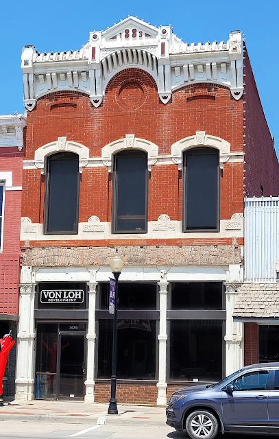
Moving further south on US Hwy 11, as we neared the Maryland State Line, we stopped at Greencastle Pennsylvania.  The "Greencastle High Line" railway depot was built by the Cumberland Valley Railroad in 1909.  It served passenger trains running between Hagerstown Maryland and Harrisburg Pennsylvania, but declining usage with advent of increased travel via automobiles after WWII, passenger service was halted.  The postcard shown above is from 1952.  To learn more about the Cumberland Valley Railroad, go to https://en.wikipedia.org/wiki/Cumberland_Valley_Railroad.

The High Line Train Station was named for it's elevated rails.  Many decades after the end of passenger service, the old depot still serves the community by promoting youth leadership.  As a matter of fact, the depot is now managed by the Greencastle Area Youth Foundation.  The Youth Foundation is a non-profit whose goals are to maintain the historical integrity of the Station, preserving its and the railroad's heritage, while providing a meeting place for area youth organizations...and at the same time, promoting local arts.  

The Greencastle Area Youth Foundation has made significant repairs to the building while establishing several displays designed to preserve the area's railroad history.  Web cams have been installed over the tracks so railfans can watch passing trains online and displays have been mounted for visiting railfans to safely monitor ongoing rail traffic.  Learn more at https://www.mightycause.com/organization/Greencastle-Area-Youth-Foundation.


One last stop in Pennsylvania before lunch... The B-Street Restaurant and Pub is located in the old McLaughlin Hotel in downtown Greencastle Pennsylvania.  The hotel was completed and opened for business in 1905.  The site has had a continuously operating restaurant since the late 1700s.  I was unable to determine what the upper floors of the old hotel are being used for now.  To learn more about the B-Street Restaurant and Pub, you can go to https//:bstreet104.com/.


No...we didn't have lunch at the B-Street Restaurant and Pub.  We'd determined that a local 'diner-style' restaurant was close by so we stopped for our lunch time repast at Home Style Family Restaurant which is located at 26 North Antrim Way in Greencastle Pennsylvania.  it was after the lunch hour so it wasn't busy when we arrived.  


We kept lunch simple... Laurie ordered a Patty Melt (burger, cheese and sauteed onion on grilled rye bread), accompanied by some potato chips.  She was happy with her choice.


I wasn't very adventuresome either but my sandwich was a little different than I expected.  I ordered the pork tenderloin sandwich...and where we come from that means a hunk of pork, breaded and fried on a bun.  My sandwich was indeed pork tenderloin but it was either grilled or fried...no breading.  Despite the surprise version of a pork tenderloin sandwich, it was very nice, not overcooked and still juicy.  Without those potato chips, it might have been a healthy meal.

The Home Style Family Restaurant in Greencastle Pennsylvania is open from 6 AM until 8 PM 6 days a week and from 7 AM until 2 PM on Sunday.  Note: 787 Google reviews give this restaurant a rating of 4.6 out of 5.0 possible points.  Check it out at https://www.facebook.com/homestylefamilyrestaurant/.

Just click on any of the photos to enlarge them... Next, non-stop through a bit of  Maryland and on into Virginia!

Thanks for stopping by for a visit!

Take Care, Big Daddy Dave

Tuesday, April 9, 2024

A Bit More Exploration…

…as the last day of our exploration of the Delmarva Peninsula wound down this past September, we took one more drive along the back roads in Talbot County near St. Michaels Maryland.  We’ve always been inclined to visit out of the way places and those ‘at the end of the road’ tend to be our favorites.

In this case, we continued following MD Hwy 33 west from St. Michaels toward Chesapeake Bay and then south when it follows the coast down to Tilghman Island.  

This is St. John’s Chapel on Tilghman Island.  It was built in 1891 at a cost of $2,000, but its history is a little complex.  The deed for the property shows that the original name was the “Lower Tilghman Methodist Episcopal Church, South”. 

The term ‘South” had a significant meaning.  John Wesley’s brand of Protestantism had spread quickly, especially among ‘working people’.  It was a less fatalistic alternative to Calvinism.  However, Wesley was an abolitionist and opposition to slavery was a problem in an area where some Methodists owned slaves.  In the end, many congregations broke away from the pro-Union parent church and formed a new “Conference”, the Methodist Episcopal Church South.  However, it is unclear how a congregation could have been split 25 years after the Civil War.  It may well have been because of a dispute between families...

This is an ongoing active church despite the population of Tilghman Island totaling only 807 residents.  In season though this is a low key but popular vacation spot for those living on the populous east shore of Chesapeake Bay.  Additionally, this appears to be a significant destination for weddings.  The chapel is located at 5160 Black Walnut Point Road.  Website: Holy Spirit Filled | St. John's Chapel | Tilghman (stjohnschapeltilghman.org).

We love little country stores.  The Tilghman Island Country Store has that ‘look’, doesn’t it?  It seems to serve many purposes.  It is a grocery store, a deli…complete with hot food items, it has beer, wine and liquor and it even has wine tastings in season.  They always offer local fresh seafood as one of their carry-out specials and in the winter oyster sandwiches and stew are favorites.  In warmer months it’s all about soft shell crab sandwiches, rockfish tenders and seafood chowder, but there are a variety of other items available as well.  The Tilghman Island Country Store is right on MD Hwy 33 on the island and you can’t miss it…

The store has 218 reviews on TripAdvisor…206 of which, (almost 95%) are either excellent or very good.  This Tilghman Island Country Store is on Facebook at https://www.facebook.com/tilghmanislandcountrystore/.

This handsome and unusual structure is the Lee House.  It is one of 13 unique “W” houses built on the island and in nearby Sherwood MD, roughly between 1890 and 1900.  Named for the first residents, it remained in the family until the 1930s when it was inherited by “Miss Leona” who operated a popular fishing resort.  She used the home for overflow guests.  In 1984 it passed onto another family…standing vacant for a while…before being purchased by The Tilghman’s Watermen’s Museum in 2010.

The Tilghman Watermen’s Museum showcases the work and culture of the islands ‘watermen’ and their families.  The museum was initially focused on capturing on video and audio, stories and experiences of the watermen before the old way of life on the island completely disappeared.  The museum also collected art…the island attracts artists…then boat models, watermen’s tools, the ‘how to’ of netting, tonging, dredging, crabbing, etc.

I decided to have a look at the video that was put together by the museum.  It was shown on PBS and it surely shows a different era and a far different way of life.  I enjoyed it.  Check it out on Chesapeake Bay Week | Growing Up on Tilghman | PBS.  The Tilghman Watermen’s Museum will reopen for the season on 5/11/24.  To learn more, go to About us / Leadership - Tilghman Watermen's Museum (tilghmanmuseum.org)

Travelers encounter a lot of drawbridges along the Florida coastline but not so many this far north. (However, I did learn that there are 15 moveable bridges in Maryland) This bridge connects Tilghman Island with the mainland.  It is a ‘new’ bridge, having been built in 1998.  It bridges ‘Knapps Narrows’, the 42 foot wide channel that flows between Chesapeake Bay and the Choptank River. 

This ‘heel trunnion rolling lift bridge with a counterweight suspended above the roadway’ replaced a replaced an earlier ‘counterweight bascule span’ bridge, a portion of which is now on display at the Chesapeake Bay Maritime Museum in St. Michaels Maryland.  The ‘new’ bridge is in operation 24 hours a day, 7 days a week and it opens about 12,000 times a year...or more than one time per hour.  It used to open partially based on the size of the boat or boats passing through the Narrows but now they have to open it fully to reduce the strain on the structure.  In season, that extra time causes delays for locals and tourists alike.

Note: If you are 'into' sailing boats and ships, Tilghman Island is home to 10 Skipjacks that are listed on the National Register of Historic Places.  To learn more about these special vessels and to see some photos, go to Skipjack (boat) - Wikipedia.

This colorful and appropriate mural helped us enjoy the wait for the drawbridge to close again.  It’s painted on the side of the Phillips Wharf Environmental Center building.  This large display of public art celebrates the Tilghman Packing Company, the local watermen and the bounties of the Chesapeake Bay.  The mural was created by a well-known local artist, Michael Rosato and it was completed in the late spring of 2021.

FYI, Michael Rosato is based in Cambridge Maryland and his murals are stunning.  Learn more at Michael Rosato Studio.

Note: The Tilghman Packing Company was founded in 1897 in an oyster-shucking house on pilings on a steamboat wharf.  I grew to include multiple operations and to employ 600 people, the majority of men and women in the area.  It was the largest employer in Talbot County.  The company closed in 1975 and not a vestige of the company remains today.  A PBS video about the packing company can be viewed at MPT Presents | Til-Made, Remembering the Tilghman Packing Company | PBS.  It is a very interesting look into the not too distant past...

When we got back from Tilghman Island Bonnie and Bill were done for the day.  But Laurie and I ‘just had to’ check out a couple more back roads.  That’s when we came across the schoolhouse pictured above.  It’s located north of Easton Maryland on MD Hwy 662.

The “Little Red Schoolhouse” was also known as the Longwoods Elementary School and the Germantown Consolidated School.  It was one of the forty-three one-room school houses in Talbot County in 1865.  It remained in use until 1967.

In the early days, the school was heated through the use of a pot-bellied stove that was the responsibility of the teacher.  First through seventh grades were taught here…with young students at the front of the room and older students in the back.  Few schools teach geography these days but it was a key curriculum item for the children along with reading, writing, arithmetic and history.  Slates or small chalkboards were used by the students as paper was very expensive.  Electric lights were added in 1936 and indoor plumbing was installed in 1951…about when my better half was born. 

After the school was closed the Talbot County Historical Society restored the schoolhouse to its original condition, the outhouses were put back and the electric lights were removed.  To learn more, just go to Little Red School House | VisitMaryland.org.

That’s all for now…  Next up – “Dinner at a Diner”.

Just click on any of the photos to enlarge them…

Thanks for Stopping by for a visit!

Take Care, Big Daddy Dave 

Tuesday, November 14, 2023

A Quick Look at Blair Nebraska

Returning from our visit to the DeSoto National Wildlife Refuge, we drove through the town of Blair Nebraska.  Before Laurie and I left East Tennessee for Omaha, I’d noted some structures in Blair that were listed on the National Register of Historic Places…so we stopped in town and took a few photos.


The first photo is just looking down Blair’s Washington Street this past summer.  The second photo shows part of the same view…only from 1913.  Blair is the county seat for Washington County Nebraska.  It was platted in 1869 when the Sioux City and Pacific Railroad reached that point.  It was named for the railroad magnate who brought the railroad to town, John Insley Blair.

Actually, the ‘fix’ may have been in play that led to this ‘new’ town.  Whether it was on purpose or by chance, the new railroad’s route missed the existing towns of DeSoto and Cuming City…so a new town was ‘needed’.  It probably wasn’t a coincidence that the 1,075 acres of land that became Blair, was purchased by John Insley Blair…who then announced his plans for the city, (which he named for himself), and then auctioned off the land to the highest bidder!

Today, Blair’s population is relatively stable with 7,790 resident as of 2020.

This photo shows the old Blair Railway Bridge over the Missouri River.  The photo was taken during the floods of 2011.  The railroad bridge was completed by the Sioux City and Pacific Railroad in late 1883.  It replaced a ferry that used to carry rail cars across the river.  This November marks the 140th anniversary of the railroad bridge.  Iowa is to the left and Nebraska, with Blair, is to the right.

The railroad bridge originally cost $1,130,000 to build.  That is equal to $34,200,000 in today’s dollars.  It’s hard to see the rail bridge in the photo as it’s dwarfed by the parallel vehicle bridge over the river that serves US Hwy 30, aka the Lincoln Highway.  At the lower left you can see the rail line approaching the bridge.

Usually I just photograph structures listed on the National Register of Historic Places.  But in this instance there were so many buildings in Blair’s downtown area that were more than 100 years old, that I just took photos of several structure despite not having any information about their history.

I loved the look of this little building at 1569 Washington Street that was built in 1890.  Reportedly it was built to serve as the post office.  From what I could find, the building is for rent and it features an open area plus 3 different offices.  Occupants over the years have included a law firm, a financial services company, a couple of mortgage firms, a builder/contractor and an excavation firm.

This is the Pierce-Warrick Building.  The exterior of the Warrick portion is identical to the Pierce section.  The building was constructed ca. 1880 and definitely before 1886.  I found a note that stated that the town’s library had been housed in the building and that it had grown too large and it was moved from the Pierce Building to the second floor of a local bank, which was named the Castetter Bank.

I couldn’t find any other history about this building.  Occupants at the time of our visit were the Healthy Human Med and Market in the Pierce segment of the building…and the Washington Street Pre-School in the Warrick (hidden) side of the structure.  Note that the low cream colored building at the left of the Pierce-Warrick building will be 100 years old in 2024.

Thanks to the efforts of local historians, I was able to learn a bit about the SAS Building…although the dates are confusing.  Originally this site was home to the first store/merchant in town.  John George Smith built a store here in 1868.  Then it gets confusing…at least to me.

The Sas Brothers were doing business in Blair by 1887.  Apparently it wasn’t at this location.  But, by 1889, W.J. Sas was in business here, selling groceries, candies and shoes.  The old Sas Brothers General Store had a string hanging from the ceiling with little buckets that were operated via a pulley system.  Customer’s payments were hauled up to the second floor and your receipt was sent back down.

By 1908, it served as The Racket Store owned by Henry Bruse.  By 1939, the building had undergone complete remodeling, greatly changing the interior.  At that point, it was the Kolterman Variety Store.  At the time of our visit one half of the first floor featured “For Rent” signs and the other half was occupied by “Vape ‘N Smoke”.

The Gamuts Building, which was built in 1881, apparently began its life as The Blair State Bank.  By 1908 the building seems to also have been home for a dentist office on the second floor, a ‘bath and shave’ operation at the basement level as well as serving as the office for the Blair Democrat Newspaper. 

I really like this building.  The exterior appears untouched and it’s been well maintained.  The interior was remodeled in 2014 and 2015, with new plumbing and electrical installed.  The building is, or perhaps was, listed for sale recently.  It offers 5,724 square feet of space and the price was set at $499,950.

The Blair Congregational Church has been on the National Register of Historic Places since 1979.  It’s affiliated with the United Church of Christ.  The church  was founded in 1870 and this ‘carpenter gothic’ structure was constructed in 1874.

Carpenter Gothic style churches are rare in Nebraska and this building is believed to be the only non-Episcopalian example of the style.  Architect Richard UpJohn was the force behind the Carpenter Gothic design in the USA…especially for small Episcopal congregations.  FYI, the architect for this church was paid $25 for his submission of the plan for the building.

This large structure formerly served as the Blair High School.  This two-story building was built in 1889 in the Richardsonian Romanesque style.  A Colonial Revival addition was built in 1929.  Today, the structure has been converted to apartments, offices and a social hall.

The architect for this large structure was John/Johann Latenser, Sr.  He was born in Liechtenstein and his practice was in Omaha, where he operated for more than 50 years.  Several of his buildings are included on the National Register.  They include the Douglas County Courthouse in Omaha.  In 1893 he was named Superintendent of Federal Buildings for a 6-state area.  Latenser was responsible for the design of at least 20 major buildings in Omaha.

This home is also listed on the National Register of Historic Places.  The Abraham Castetter House was built was built in 1876.  The design was a combination of the Second Empire and Eclectic styles.  The home was located in what was then referred to as the “Silk Stocking Row” of Blair. 

Abraham Castetter served as Washington County’s County Clerk and subsequently founded a bank named after himself...which, as mentioned above, served at the town's library for a while.  As a prominent businessman, Castetter donated land which became known as “Castetter Park”, now part of the City Park of Blair.  This home was held by direct family members until 1963.

While this building is quite obviously old, I couldn’t find a date when it was built.  Apparently it’s been a law firm office for a number of years.  It served as the Hopkins Law Office before the Johnson and Pekny firm occupied the space.  Johnson and Pekny, Attorneys at Law, have offices in Omaha and Plattsmouth Nebraska as well.

I love those old shutters as well as the brick work under the upper windows!

This building, with its fairly close to original exterior, even at for most of the lower façade, was built in 1883.  Currently it’s occupied by Von Loh Development.  That company has recently received approval to build an apartment on the building’s second floor.

The only reason that I was able to determine a bit of history about this building stemmed from that 1913 postcard…the second photo at the beginning of this post.  On the postcard you can see that ornate façade as well as some signage on the side of the structure.  As of 1913, this handsome building was home to Blair Clothing.  The store featured ‘Men’s, Boy’s, and Youth’s clothing along with Men’s furnishings and Fine Shoes


This is the former home of the ‘Odd Fellows’.  Unfortunately, the lower portion of the structure has been badly modified and ‘modernized’.  Although the ‘Oddfellows’ are one of the earliest and oldest fraternal societies, their early history and even why they are called the ‘odd fellows’ is obscure and not well documented.  Today the Independent Order of the Odd Fellows has 600,000 members in 26 different countries.  Their state purpose is to “Visit the sick, relieve the distressed, bury the dead and educate the orphan”.


This brick structure was built in 1892 after “A Big Blaze” as described in the Blair Courier newspaper, destroyed the original I.O.O.F. wooden structure.  I was able to determine that Mr. O.C. Thompson operated the “Bee Hive Store” (groceries and gifts) on the ground floor of the building.  In the 1930s and 1940s the building was leased by the Safeway Store.  In 1945, it became a restaurant under various names until about 1971.  At that point, it became a clothing store for a number of years.  It was during this time that the Odd Fellows sold the building to the clothing store owners.   


Because I didn’t get a photo of the Washington County Courthouse that showed the central dome or the whole roof area, I borrowed the second picture from the Internet.  This style is referred to as “Property Type, County Capitol” with Romanesque Revival influences, and it is listed on the National Register.  The courthouse was completed in 1891.  The structure is basically unaltered.  Unusual symbolic and decorative external features include painted metal forms of cornucopia, wheat and pumpkins (the fertile land), as well as a ship in full sale (the immigrant experience).  Shields are present as well…symbolizing county government.  The statue in front of the west side of the courthouse is a memorial to Union soldiers in the Civil War.

As was common in the early days, residents from various towns strove to have their city designated as the county seat.  In the 1850s and 1860s, a crowd of De Soto town supporters laid siege on the log courthouse at Fort Calhoun and one man was killed.  After a 2-day stand-off, Fort Calhoun surrendered the records.  In the end, it was all for naught as Blair took the title in 1869.  The presence of the railroad and a booming city carried the day.  The town was growing so quickly that local brickyards were turning out 1.5 million bricks per year in an effort to meet the demand. 

Note: The Mormons, (aka the Latter Day Saints), stopped in Washington County in 1846, after fleeing persecution and attacks at Nauvoo Illinois.  They were under the leadership of Brigham Young and Orson Pratt.  The remained near the town of De Soto for several years before moving on to Utah, where they settled permanently.

That’s all for now!  Just click on any of the photos to enlarge them…

Thanks for stopping by for a visit! 

Take Care, Big Daddy Dave

Tuesday, September 19, 2023

Road Trip – Missouri (Part 7)

 Road Trip – Missouri (Part 7)

…continuing north along MO Hwy 5, after crossing US Hwy 50, we came to Versailles Missouri.

After a little time, we came to Versailles Missouri, the county seat of Morgan County.  This 2-story, 85 feet by 85’ Second Empire style brick building was constructed on a limestone block foundation in 1889.  That cupola is quite different than most with some decorative features done in cast iron.  The mansard style corner towers or pavilions are eye-catching as well. 

Morgan County’s first courthouse in Versailles was log building that was purchased, taken apart and then rebuilt on the town square in 1836.  It served the purpose for about 7 years, at which time it was removed and a more permanent brick courthouse was completed in 1844.  The newer building was the courthouse for about 40 years.

Actually, a major fire in October of 1886 almost wiped out the town.  Then only 5 months later, in March of 1887, a second fire destroyed all the businesses on 2 sides of the town square…as well as the old 1844 courthouse.  The new replacement courthouse was already under construction when the fire occurred but legal issues regarding the property tied up its completion, so it took about 2 years to complete it.

The Bank of Versailles was definitely built to impress the area’s citizens and to assure them that it was a good place to put their money.  I like the fact that they’ve preserved that solid “bank” exterior image.  The Bank of Versailles opened for business in November of 1882 and it has always been locally-owned and operated.  It was started by 5 shareholders with $5,000 between them.  The interior of this building, the bank’s main facility, was remodeled in 1958.  So…let’s see.  The remodeling took place a mere 65 years ago and the bank has been operating for 141 years…not bad!

I included this handsome old red brick building in downtown Versailles, just because I liked the almost unaltered look of it.

Versailles History: Morgan County was established in 1833, at a time when Native Americans from the Osage Indian tribe still lived in the area.  Versailles was platted/founded only 2 years later.  The town was named after the Palace of Versailles in France, possibly by county residents who were of French descent.  

By 1940, the village had grown and it had a population of 70 and it included 25 buildings!  There was a 3-room tavern and inn, a livery stable, a stagecoach stop, a blacksmith shop, boarding house, a general store and a carpentry shop all built around the town square.  By 1894, Versailles had gas lights and by 1904 it had electric lights.  In 1909 the town even had an ice plant!  The Rock Island Railroad was completed from St. Louis to Kansas City through the city in 1903, just in time for folks from Morgan County to attend the 1904 World’s Fair in St. Louis.  Today Versailles has a population of 2,539 and Morgan County has just a little over 21,000 residents.

In 1908, a Sanborn Insurance Map showed that a theater was operating in the southern half of the brick addition to Versailles’s Martin Hotel.  They also disclose that the Royal Theater had opened by 1914.  I love seeing old small to medium size towns maintaining or reutilizing old ‘opera houses’ or movie theaters.  The Royal Theater has been reconfigured inside and its former balcony is gone.  These days, the theater is very much alive, now featuring live plays and other entertainment.  This coming October, the theater will present 8 performances of Andrew Lloyd Webber’s Play, “Cats”.  To learn more, go to The Royal Theatre.

Note: I was unfamiliar with the Sanborn Map Company until I ran across the note on the Royal Theater.  Back in the early days and well into the latter half of the 1900s, maps were created to allow fire insurance companies to assess their total liability in urbanized areas of the USA.  These maps contain detailed information about properties and building for about 12,000 American cities over many, many years.  They are an important resource for historical research as they document changes over the decades.  Sanborn had a virtual lock on this business for many years...


The Martin Hotel was built in Versailles in 1877, with a brick 2-story addition being added in 1884.  Some guests would arrive via the Jefferson City t0 Springfield MO stagecoach line that passed through town.  The hotel also had a stagecoach the connected with the Missouri Pacific Railroad in Tipton Missouri.  Civil War soldiers and famous people such as P.T. Barnum and the outlaw Jesse James.

The rooms in the Martin Hotel had the necessary bedding, a washstand with a water pitcher and a bowl as well as a chamber pot to serve as a toilet.  Also, each room had a wood stove and they had a heavy rope that was attached to the floor.  In case of a fire, the rope could be tossed out the window and used as a fire escape.  An early Sanborn map showed that as of 1894, the room that eventually became the early theater, was used as a sample room.  Electricity was installed in 1908 and by 1923, interior plumbing was added. 

The Martin Hotel was operated by the same family until 1967 or 1974, (depending on the source of information), when it was purchased by the Morgan County Historical Museum.  The old hotel registers include signatures of Civil War soldiers who stopped for room and board.  The museum also features a barbershop; a weaving/quilt room; Civil War relics; an early rural school room, a carbide chandelier, 2 folding covered-wagon rockers and much more.

The museum is open from May through October.  To learn more, their website is at Morgan County Historical Society and Museum (morganmomuseum.org).

As we came to the town of Tipton Missouri, we stopped to take a picture of the Harrison School National Historic Site.  Harrison School is not only listed on the Register of Historic Places but it’s also on the Smithsonian Institution’s National Museum of African American History and Culture’s Community website.  It is the last remaining school in Moniteau County Missouri from the 1800s that was built for black students.

The school’s stone foundation was cut, quarried and laid by some of Tipton’s formerly enslaved black citizens.  This 2-room brick schoolhouse opened in the fall of 1890.  It initially only taught students from the first to the sixth grades.  From 1890 until 1936 and then from 1942 until 1954, black students who wanted to continue to high school had to enroll in high schools in Sedalia, Kansas City, Jefferson City or St. Louis Missouri.  Of course, such a decision required transportation, self-funding and finding somewhere to live while at school.

Tipton’s high school was integrated in 1954 but elementary students weren’t integrated into Tipton Public Schools until 1957, and the Harrison School was closed.  This historic school could use a little tender loving care…

This handsome mansion is also located in Tipton Missouri.  The Maclay Mansion, aka the Rosehill Seminary was completed in 1860 and it was briefly used as a female seminary until the beginning of the Civil War, at which time it became a private residence.  During the war it is thought that General John Fremont used the home as his headquarters during his stay in town in 1861.  It is also claimed that Confederate leaning ‘bushwhackers’ attempted to burn the house down during the war.  Since Confederate soldiers under General Joseph Shelby did burn down the railroad depot and a number of railcars in 1862, there may be some credence to the claim about trying to burn down this big home.

This 3-story, 17 room brick home served as a private residence until about 1920.  When the home was purchased by the Maclay/Gleim family in 1865, it wasn’t long before 3 bachelor brothers, 5 widowed sisters and their children were all living in the home.  After 1920, Maclay family descendants used the property for special events and as a summer home.  In 1983, the mansion was given to the Friends of the Maclay Home, Inc.

The mansion is a great example of antebellum brick architecture in Missouri.  It is filled with original furnishings and clothing that belonged to the Maclay family over the years.  It’s described as a time capsule of life during the second half of the 1800s.  To learn more, go to Maclay Home | Tipton MO | Facebook.

History: William Tipton Seely founded the town of Tipton.  He was a veteran of the War of 1812 and he’d been awarded with the land for his service.  He set up a general store on the Butterfield Overland Stage Line route.  Then he arranged for the Pacific Railroad line to cross through his property.  The town was surveyed in March of 1858 and Seely was selling off his lots to build the town.  By the time the railroad was completed, more than 25o people called Tipton home.  Today the town has a population of a little over 2,900 people.

I followed MO Hwy 5 north to MO Road B and then on to Bunceton Missouri.  My goal was the former Missouri Pacific Depot at 111 East Main Street.  I am not sure when the depot was built but I do know that it was constructed by the Osage Valley and Southern Kansas Railroad probably sometime between 1870 and 1880.  It was shortly after 1880 when the Missouri Pacific Railroad took over the Osage Valley railroad.  The MoPac caboose next to the old depot is a model M930 with a wide vision cupola.  It was made by the International Car Company and it’s about 38 feet long.  The old depot now serves as the Bunceton City Hall.

Bunceton was laid out and platted in 1868.  It was named for an early county resident and a post office has been in operation in town since the year the town was platted.  In 1980, Bunceton Missouri’s voters elected the United States’ first openly gay mayor.  The town has 334 residents.

Bunceton and its immediate area has experienced a bit of history.  The Civil War Battle of Lone Jack was fought nearby.  It was an intense battle with over 200 soldiers killed.  In the 1800s, Bunceton was a stop along the famous Santa Fe Trail.  The Trail of Tears, with the ‘removal’ of Native Americans from their ancestral homes, also passed through the town. 

From Bunceton we followed MO Road J back to MO Hwy 5 north.

When MO Hwy 5 intersected with I-75 we followed it west to US Hwy 65 north to the City of Marshall Missouri.  We had several historic and/or strange sites to visit in Marshall…

The Buckner House, a historical 2-story, 3 bay Classic Revival home was built in 1906.  This 48 foot square home sits on a cut stone and concrete foundation.  We love that fantastic double porch!  It is considered to be representative of the level of prosperity and taste achieved by an elite family prior to World War 1. 

The home is in excellent condition and almost completely unaltered.  It was presented to the Saline County Missouri Historical Society by the Buckner family in 1982.  A little research revealed that the interior of the Buckner home is documented via a series of photographs posted on Zillow.  The interior is fabulous and it looks pristine.  You can check it out at https://www.zillow.com/homedetails/125-N-Brunswick-Ave-Marshall-MO-65340/239599258_zpid/.

The Chicago and Alton Railroad Depot, aka the Illinois Central Gulf Depot was built in 1906 for the Chicago and Alton Railroad.  This brick and stone structure with both Jacobethan Revival and Mission Revival style elements is about 113 feet long beside the tracks, which are still in use.  Other sources simply list the design style as Spanish Revival.  It served as both a passenger depot and freight depot for Marshall.  Unfortunately, it is now abandoned.

That’s about it for now… Just click on any of the photos to enlarge them.

Thanks for stopping by and patiently following our road trip through Missouri!

Take Care, Big Daddy Dave