Showing posts with label National Parks. Show all posts

Friday, July 18, 2025

Moving On...Changing My Focus

It was on July 18, 2010, 15 years ago today, that I first posted something on my blog site.  I have regularly published posts regarding historical, food, family, travel and restaurant experiences for most of the past many years.  At one point I was posting to the site 3 times every week.   Most recently, it's been twice a week.

I've decided to cease any regular publications/posts to the site.  Not gone...still will publish something from time to time as the spirit moves me, but my focus is moving elsewhere.  I want to spend more time researching our family histories and I've gotten much more involved with a local Knoxville collector's club.  I do enjoy the time spent in that endeavor...even with the work involved. 

What follows are a scattering of the many photos dating as far back as last October...a sampling of those taken near the conclusion of our long road trip through parts of Tennessee, Kentucky, Ohio, West Virginia, Pennsylvania, New York and Virginia.  I'd never completed the Virginia portion of the trip...


This is the entrance to the Reeves Museum of Ceramics at Washington and Lee University in Lexington Virginia.  The Reeves collection showcases one of America's best collections of Chinese export porcelain as well as European and American ceramics made between 1500 and 1900.

FYI, Washington and Lee University is the 9th oldest college in the USA.  Originally known as Liberty Hall Academy, it was renamed Washington Academy in 1796 and Washington College in 1813.  A gift of stocks from George Washington had saved the school from financial ruin.  Robert E. Lee, who had led Confederate forces throughout the Civil War, had previously been the Superintendent of the West Point Military Academy.  A few months after the war, he became President of Washington College and he helped build the university for the future.

In today's highly charged political atmosphere, Lee's name being attached to this University has been controversial.  For the university's outlook on this subject, go to https://www.wlu.edu/about-w-l/university-history/university-namesakes.


During our visit, there was a exhibition of ceramics adjacent to artwork with blank spaces in the paintings that are related to the ceramics.  I still don't get it...but both Laurie and I do love ceramics and this plate was a stunner!


I just had to include this 'fowl' piece of porcelain in my post.  Love the brilliant colors involved!  


Then there was this gorgeous brown and yellow teapot with raised decorations.  This teapot from the Yixing Dynasty teapot dates somewhere between 1725 - 1775.


This stunning hard paste porcelain 'tea pot' from China didn't start its life as a tea pot, but rather as a wine pot.  The English later repurposed it as a teapot.  Note the 'bamboo bundle' shape that was created by a master ceramics maker sometime between 1700 and 1720.


Moving on down the road, it was time to find a place for dinner.  Research had revealed the possibility of a fine German dinner near Staunton Virginia.  The Edelweiss Restaurant is a log structure in the Blue Ridge Mountains.  The family that built it came from Karlsruhe Germany.  The menu is loaded with German specialties, something one doesn't see very often.

While Edelweiss is well rated on the Internet, Laurie and I weren't feeling it... The food was decent but not great and the service was rushed.  This restaurant is popular with long waits for customers so maybe our lack of enthusiasm isn't typical.  Check it out and give Edelweiss a try.  Let us know what you think... Website: https://edelweissvirginia.com/.


I love taking photos like this and imagining what might have been... Located at the eastern foot of the Blue Ridge Mountains on US Hwy. 60 in Amherst County Virginia, Forks of Buffalo refers to the place where the North and South Forks of the Buffalo River come together.


Since I like researching places, I came across this photo from the Forks of the Buffalo area, showing the Myers' Cash Store, United States Post Office and Esso Gas Station.  Perhaps the early to mid-1960s, the store opened in 1937.  Unfortunately, I also came across another photo from December of 2024, only 2 months after I took that first photo, now showing that the front of the old building had fallen down... Timing is everything.


This well preserved and restored railway depot is located at Amherst Virginia.  Amherst was founded in 1807 and it is the county seat for the county of the same name.  The town's population has never been much higher than its current level of about 2,200 residents.

Amherst was first known as Dearborn and the first depot here was completed in the late 1800s for the Orange and Alexandria Railroad.  It was replaced in the late fall of 1913 by the Southern Railway.  As was typical, the ticket booth extended outward from the center facing the tracks, with waiting rooms on each side...one for black folks and the other for white folks.  Three passenger trains stopped at the depot every day until the mid-1940s.  Passenger service was completely discontinued during the 1960s and finally freight service ceased in the mid-1970s.


So...just where is this old structure located?  Our next significant stop was at the Appomattox Courthouse National Historic Park at the village of Appomattox Courthouse...redundant I know.  This is not the original Appomattox Courthouse, but rather a reconstruction.

In the 1800s the original courthouse gave its name to the village around it.  As many of us know, Confederate General Robert E. Lee surrendered his army here in 1865.  I always thought that Lee had surrendered to Grant at the courthouse but the courthouse was closed that day so the surrender took place in a nearby home.  In any case the village was already in a state of decline in the 1850s.  The original courthouse burned down in 1892 and the county seat was relocated.  This structure was rebuilt in 1964 and it now serves at the Visitor's Center for the more than 1,700 acre Appomattox Courthouse National Historical Park.


So this is the house...or an almost exact replica of the house...where Lee surrendered to Grant, virtually bringing America's long and painful Civil War to an end.  This is the McLean House at the Appomattox Courthouse National Historic Park and it was chosen for the surrender as it was the most substantial home or building in the Village.

The McLean House was originally built by Charles Raine in 1848.  It had served as a tavern/inn and it was sold to Wilmer McLean in 1863.  In an interesting historical quirk of fate, the First Battle of Bull Run (Manassas) took place on McLean's farm.  Seeking to avoid the war, and too old to serve in the Confederate Army, McLean moved here to 'avoid the war'.


This is a recreation of the setting where Lee formally surrendered to Ulysses S. Grant.  The original furniture is in the possession of the Smithsonian and the Chicago History Museum.

The terms of surrender were: "The officers to give their individual paroles not to take up arms against the government of the United States until properly exchanged, and each company or regimental commander to sign a like parole for the men of their commands,"... neither "side arms of the officers nor their private horses or baggage" to be surrendered; and, as many privates in the Confederate Army owned horses and mules, all horses and mules claimed by men in the Confederate Army to be left in their possession.

As for the McLean house, Wilmer McLean was broke as all his money was in Confederate dollars, which he'd accumulated by running sugar through the Union blockade during the war.  Ownership passed from one person to one scheme or another.  At one point it was disassembled and labeled for possible reconstruction as an attraction in Washington D.C.  That project never got off the ground and much of what was left of the house was pilfered over the years.  The re-built house was opened to the public on April 9, 1949.  Over 5,000 of the home's original bricks were used in the construction.

To learn more about the Appomattox Courthouse National Historical Park and to plan a visit, go to https://www.nps.gov/apco/index.htm. 


This is the Booker T. Washington National Monument near Hardy Virginia.  Booker T. Washington was born a slave on the 207-acre farm of James Burroughs in April of 1856.  Following the Civil War, he became the first principal of  the Tuskegee Normal and Industrial School.  Later, as an advisor and confidant of President Theodore Roosevelt, an author and orator, he became the most influential African American of his era.


Booker T. Washington (1856 - 1919)

To learn more about Booker T. Washington, you can go to https://en.wikipedia.org/wiki/Booker_T._Washington.


This National Monument preserves portions of the tobacco farm where Booker T. Washington was born and where he lived for the first 9 years of his life.  The facility also provides interpretation of Washington's life and achievements as well as an interpretation of slavery and farming in the 1850s through the use of buildings, gardens, crafts and animals.

You can learn more about The Booker T. Washington National Monument at https://www.nps.gov/bowa/index.htm.  

The last stop on our long but interesting and relaxing road trip was of course, dinner on the last night of the trip.  We were tired and looking forward to getting home.  The decision was made that we should go casual for our final meal on the road so we picked JJ's Restaurant and Sports Bar in Abingdon Virginia from my list of dining options.  Laurie stuck to soup and cornbread and I went for fried catfish, beans, coleslaw and cornbread.  The food wasn't gourmet but it was tasty, reasonably priced and satisfying.

JJ's Restaurant and Sports Bar is located at 115 Charwood Drive in Abingdon Virginia.  Open daily for lunch and dinner.  Phone: 276-525-4999.  Website: https://www.eatatjjs.com/.

As I mentioned at the start of this post, I'll be back from time to time and I'll also check in on those who I've been following...

Just click on any of the photos you'd like to enlarge.

Thanks for stopping by for a visit!

Take Care...and, as the saying from the 50's (the era of 45 rpm records), "I'll see you on the flip side".

Big Daddy Dave

Tuesday, March 18, 2025

Through the Forest to Luray Virginia

...continuing with our September/October 2024 road trip...the final phase of which was working our way south through Virginia toward our home in East Tennessee.  After our brief stop in Edinburg, we head south and east on back roads toward Luray Virginia. 


Following VA Hwy 675, we wandered through a narrow portion of the George Washington National Forest.  This particular National Forest covers 1,064,176 acres, about 33,600 acres of which are located in Page and Warren Counties that we were passing through. 

Administratively, the George Washington and Jefferson National Forests are managed as one unit.  Between the 2, a total of 2,800 square miles of land is protected.  Almost 140,000 acres of the National Forest have been designated at "wilderness areas"...no vehicles and no development allowed.

Note: These two National Forests cover an area larger than the State of Delaware.


This is a great example of our favorite style of highway driving!  Peaceful and almost no traffic... We wandered through the woods across the ridge that is part of this portion of the George Washington National Forest.


This view was one of our 'rewards' from following this byway from Interstate I-81 toward Luray.  That's the part of the Blue Ridge Mountains, itself a portion of the 2,000 mile long Appalachian Mountain chain.  I'm guessing that those little red flags will be replaced by guardrails.  


Once we reached Luray Virginia, our goal was the Luray Caverns attraction.  The fact is that we've done a lot of cave walking over the years and at my age and stage, there is no way that I could tour a cave.  But, the fact is that Luray Caverns is much more that an interesting big cave complex.  

I had called ahead and talked to the front office at Luray Caverns.  I told them that I was unable to tour the caves but that I sure would like to visit the remainder of the attraction.  Was there a way we could do that without fronting $64.00 for Cavern tickets?  I was told that all we had to do was to tell the admissions that we could visit the rest of the attraction without paying...and if there was a problem, just have them call the office.  Now this was a deal!

So, other than the caverns, (obviously the main attraction), there are 4 other attractions at Luray Caverns.  There is a Rope Adventure Park (not for us), The Garden Maze (not for us), Car and Carriage Museum (yea!), Shenandoah History Village (yea) and, there also is a toy museum. (ok) Plenty to see and do!


The toy collection or museum at Luray Caverns isn't hyped as much as the other attractions but Laurie and I both enjoyed wandering down "memory lane".  This large model railway display occupies the center of the space.  


Laurie took this photo of the railway bridge over the canyon.  If you look closely, you can see the images of a couple of toy airplanes hanging from the ceiling as well as a carousel horse behind the railway display's church steeple. 


I've always been fascinated by miniatures and love the close-up detail one can create.  I do remember when Trailways and Greyhound buses looked like the one in this photo...and love that Ford 'ragtop'! 


Being from the Midwest, we never saw electric power locomotives like this one.  I still prefer the look of, if not the smoke from, old time coal burning locomotives.


This is one of the few photos we took of toys that weren't part of the train exhibit.  Its the only one that I liked.  While a variety of "Rocket Racer" cars were produced and can be bought on the Internet, this is one of the truly rare ones.  From the 1930s, this is a rare Marx Rocket Racer Tin Lithograph Wind Up Toy.  It is roughly 18" long.  I found one on sale on eBay that isn't as pristine as this one is.  Asking price $499.95.

If you are over 55 years old, you should remember Marx toys.  Louis Marx and Company was in business from 1919 until 1980.  Toys that the company produced included tin toys of many types, toy soldiers, toy guns, action figures, dolls, toy cars and model trains.  Rock'em Sock'em Robots and Big Wheels tricycles were Marx products.  Marx's larger and costlier toys were staple items for catalog and departments store retailers, including J.C. Penney, Sears and Montgomery Ward. (The latter company being one of my key career stops)


These last two photos in this blog post are indeed children's toys, but they also lead into future posts from Luray Caverns.  Note that these are technically 'wheeled vehicles'.

Reading the plaque at this angle is challenging, so I'll do it for you.  This elaborate child's goat cart...powered by two 'billy' goats...was built in 1905 at the J. W. Clinedirst Factory in New Market Virginia.  Why was it so fancy?  Simple answer...it was built for the factory owner's grandchildren.  Looking on-line, no actual goat powered carts are shown that even approximate the look of this luxury toy.


Technically, this isn't a child's toy but rather a toy or prop designed to entertain children.  This horse tricycle was built sometime in the mid-1920s or 1930s for clowns to use in a circus.  It moved by pumping the handlebars up and down and as it moved, it 'rocked' like a child's rocking horse.

Do you remember the excitement when the traveling circus came to town?  Laurie and I remember the colorful and very impressive Ringling Bros. and Barnum and Baily Circus train passing through Des Plaines Illinois.  On one occasion Laurie visited the site of the fair near O'Hare Airport in Chicago... Her mission was to collect animal 'poop' from the elephants, horses and tigers that she could use to fertilize her flower beds.  It was free!  

The Ringling Bros. and Barnum & Bailey Circus, the largest circus in the USA, closed its traditional big top in 2017.  New types of entertainment including video games as well as animal welfare campaigns significantly contributed to the demise of most traveling circuses.  In 1905, there were 46 traveling circuses in the USA and by 1937 there were about 300 traveling circuses or shows of varying sizes.  Today there are just a handful of relatively small traveling circuses, many of which don't feature 'wild' animals. 

Just click on any of the photos to enlarge them...

Thanks for stopping by for a visit!

Take Care, Big Daddy Dave

Friday, December 27, 2024

Johnstown Pennsylvania and the 1899 Flood Disaster

Some time ago we read a book entitled "The Johnstown Flood of 1889...The Story of the Deadliest Flood in American History" by the Charles River Editors.  We became curious about Johnstown Pennsylvania and the area around it.  As a consequence, I chose Johnstown as an overnight stop on our multi-state road trip.  The history of the flood is one of privilege and neglect.   


Our first stop when we arrived in Johnstown was the Johnstown Flood Museum.  It's located in the former Johnstown Public Library Building.  The Johnstown Library was originally built in 1879 by the Cambria Iron Works, a large iron and steel producer that continued to operate, (as part of a larger company), in the Johnstown area until the early 1990s.

Cambria had 5 different manufacturing sites in and around Johnstown.  All of them were located along either the Conemaugh or Little Conemaugh Rivers.  Each of these former sites represents a different phase of development and growth of the steel industry.  All 5 areas now comprise a National Historic Landmark District.


In any case the original library was destroyed in the horrific Johnstown flood that occurred on May 31, 1889.  It was rebuilt in the French Gothic Revival style by the Andrew Carnegie Fund in 1891.  The fund provided funds covering maintenance and other costs until 1930.  It is an impressive structure...

A bit of background for those unfamiliar with the Johnstown Flood of 1889.  This devastating disaster happened on May 31st, following the collapse of the South Fork Dam which was located 14 miles upstream from the city.  Heavy rainfall had trailed over the area for several days and the dam's failure released 20,000,000 tons of water down the valley and into Johnstown.


This steel railing from a bridge over Paint Creek was found wrapped around a tree a flood in July of 1977.  So why is it in the Johnstown Flood Museum?  It is meant to show visitors what power fast flowing flood water has...  In actuality, little actual debris from the flood remains 135 years after the deadly flood took place.


This bottle of dirty water is an artifact from the flood...sort of.  The bottle contains Johnstown floodwater taken as a souvenir just one day after the disaster.  A couple who collected the water came to Johnstown the day after the flood on a sightseeing excursion that had been organized in Altoona Pennsylvania.  People never seek to amaze me...and disappoint me...   

So just how bad was the devastation caused by the Johnstown Flood of 1877?  Over 2,200 people were killed, including 99 families and almost 400 children.  Tens of thousands were left homeless and without jobs.  Four square miles of the city including much of the Cambria Iron Works was completely destroyed.  What a 'great' tourist attraction... Sad!


Most of the exhibits at the Johnstown Flood Museum consists of mindboggling photos.  Note the destroyed locomotive and train in the first photo.  The home shown above with the tree driven through it belonged to the Schultz family.  The home came to rest a half mile from its foundation.  Somehow, all 6 people who lived here survived the flood.


As I mentioned earlier, many of the items that survived the flood or were recovered from it are small 'relics' from the disaster.  The pitcher came from the severely damages home of the Wesner family.  The small items in the middle were recovered from one of the flood victim's pockets.  The items include a change purse, a newspaper clipping and a notebook from the family store.  I didn't identify the large item on the right.

The South Fork Dam was originally built by Pennsylvania between on the Little Conemaugh River between 1838 and 1853 as part of a cross-state canal system.  With the growth of the railroads, the State sold the canal and dam to the Pennsylvania Railroad...and then the railroad sold it to private interests.  A group of wealthy investors/speculators, including Henry Clay Frick, purchased the reservoir, modified it and converted it into a private resort lake for wealthy business men.


Downtown Johnstown after the flood...

The investment group lowered the dam so it was wide enough for a road.  They also put a fish screen in the spillway.  A system of relief pipes and valves had been previously sold off for scrap and they weren't replace.  There was no way to safely lower the lake's water level in case of an emergency.

The investors built cottages and a clubhouse, creating the South Fork Fishing and Hunting Club.  It was an exclusive and private mountain retreat.  Membership included more than 50 wealthy steel, coal and railroad industrialists.


Relief workers removing a body from the chaotic flood debris.

Lake Conemaugh at the club's site was 450 feet above Johnstown.  Like the terrain involved in the recent flooding disaster that hammered North Carolina and northeastern Tennessee, the area is a series of hills, low mountains and narrow river valleys.  It's been estimated that up to 10 inches of rain fell in the area in just 24 hours.  Small creeks became roaring torrents, telegraph lines were downed and rail lines were washed away.  At the Club, the water was almost cresting the dam.

A group of men tried to save the face of the dam by working to unclog the spillway where an iron grate and the broken fish trap had been obstructed with debris from the flooding.  Attempts to warn Johnstown of the flood risk were disregarded as there had been many alerts before and nothing had happened.  Just before 3 PM in the afternoon, the dam failed.


Another souvenir from the disaster...Mainstreet in Johnstown.  Survivors or sightseers?

As the flood waters churned on downstream toward Johnstown, it picked up debris...trees, houses and animals.  The flood was momentarily slowed when debris jammed against a stone railroad bridge.  Seven minutes later, the bridge collapsed.  Because of the water's delay at the bridge, the flood gained renewed hydraulic pressure.  This resulted in a stronger and more violent wave of water hitting places downstream

The small town of Mineral Point, one mile below that railroad bridge, was the first populated place that was hit with this accelerated force.  About 30 families lived along the village's single street.  Following the flood, no structures, no topsoil and no subsoil remained at Mineral Point...only the bedrock remained.


East Conemaugh was the next populated area hit by the flood.  As per witnesses, the water was described as almost obscured by the debris, looking more like a "huge hill rolling over and over".  An engineer in the town's railyard in his locomotive heard and felt the approaching flood.  He threw his locomotive in reverse and raced back toward the village, his whistle blowing constantly.  His warning saved many people who raced to high ground.

When the flood hit, it picked up the still moving locomotive and floated it aside.  The engineer survived but at least 50 people in the village died...including roughly 25 passengers stranded on trains along the way.

The Stone Pennsylvania Railway Bridge, shown in the photo above, was as very substantial structure.  In the picture, it shows debris from the flood stacked up against the bridge.  It included twisted steel rails, boxcars, entire buildings and the bodies of many of the flood's victims.  The surge backed up another small river and it resulted in a second wave of flood water and debris that hit the city from a different direction.

The debris then caught fire and it burned for 3 days.  At least 80 people died in the debris.  When the water receded the pile of debris covered 30 acres and it reached up to 70 feet deep.  It took workers 3 months to remove the accumulated mass, partly due to the huge quantity of barbed wire from the Ironworks.


Before and After Pictures of Johnstown.  Different angles where the rivers come together.

Fifty-seven minutes after the dam collapsed, the flood hit Johnstown.  Residents were trapped as the wall of debris and water bore down on them.  The flood surge hit speeds of 40 miles an hour (64 km/h) and reached a height of 60 feet (18 m) in places.  Many tried to escape by running toward high ground.  However many were crushed by pieces of debris or became entangled in the barbed wire from the wire factory upstream.  Of the known dead, 777 people were never identified.


After the flood, The American Red Cross, led by Clara Barton with 50 volunteers, initiated its first major disaster relief effort.  The growing Red Cross team built shelters for survivors in large buildings known as "Red Cross Hotels".  They provided free lodging, meals and other necessities.  The large 2-story hotel had 34 rooms, laundry, kitchen, bathrooms with hot and cold water and a dining hall.  Barton stayed in Johnstown for more that 5 months.  Support for the victims came from all over the USA as well as 18 other countries.  Donations totaled $3,742,818...the equivalent of $128,251,000 in today's dollars.

Many survivors blamed the members of the South Fork Fishing and Hunting Club for the modifications that weakened the dam as well as for improper maintenance.  Lawsuits were initiated but the Club's attorneys, (also club members), successfully argued that the dam failure was a natural disaster...an act of God.  No legal compensation was ever paid to the survivors or the families of those who died.  This legal 'failure' led to changes redefining liability.  About half of the club members donated thousands of dollars to the relief efforts...and of course Carnegie built the library.

For information about the Johnstown Flood Museum, you can go to https://www.jaha.org/attractions/johnstown-flood-museum/.  We didn't visit the other Flood memorial, The Johnstown National Flood Memorial at the site of the South Fork Fishing and Hunting Club.  Operated by the National Park Service, visitors can view the remaining portions of the dam, the guest cottages, the clubhouse and related exhibits at the Visitors Center.  Check it out at https://www.nps.gov/jofl/index.htm.  

Just click on any of the photos to enlarge them...

Note: Many of the photos came from the photos on-line and a Red Cross Site.  Wikipedia was the source of much of the information and in some cases, the wording was as well.

Thanks for stopping by for a visit!

Take Care, Big Daddy Dave

Friday, October 18, 2024

Focusing on Railroads...Depots and a Little History (#3)

OK, I'm back at it...into my series that revisits groups of my favorite road-trip railway depot photos.  Moving a bit further back in my blogging history, this group of photos begins in early 2019 and ends in mid-2018.  Of course some of the most interesting depot photos I've taken were of derelict depots with interesting architecture...some of them quite massive.  But I decided to go with the positive photos.  I hope that railroad and railway depot fans agree with me...


This classic railway station with the covered portico is located at the Shelburne Museum near Burlington Vermont.  The depot once served as the original depot for the town of Shelburne.  The station was built in 1890, serving passengers for both the Central Vermont and Rutland Railroads.  It was designed by the same architect who designed the nearby Vanderbilt-Webb estate.  The founder of the Museum, Electra Havemeyer Webb and her family frequently used the depot for their trips to New York City.  Rail service to Shelburne ceased in 1953 and Mrs. Webb had the station moved to its current location at the museum. 

Note: The steam locomotive peeking out of its protective shed, No. 220, was built by the American Locomotive Company in 1915 for the Central Vermont Railway.  This locomotive became known as the 'Locomotive of the Presidents", as it powered special trains carrying Presidents Coolidge, Hoover, F.D. Roosevelt and Eisenhower.


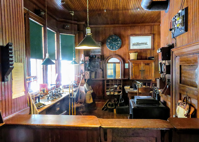
The Shelburne Depot also serves as a railway museum.  Exhibits include waiting rooms for men and women, the stationmaster's office, telegraphic equipment, maps, historic photos, early telephone equipment, and much more.


I thought that this classic little railway depot was built for the township of Milton Maine in 1873.  It was constructed by the Maine Central Railroad.  Further research indicates that it served as the Depot for Jay (The Bridge) Maine.  I did find a post card showing this depot, that was dated in 1914.  At the time we stopped by this 512 sq. ft. structure was listed for sale at $50,000.  I discovered that it sold for $42,500.  Someone new now owns a little piece of railway history.


The Gilead Maine Railway Station was built in 1851.  It is the oldest known surviving railroad depot in the State of Maine as well as the oldest surviving depot that served the former Grand Trunk Railway.  It was relocated to the town of Auburn Maine for about 20 years but it was returned to Gilead in 2001.  It is maintained by the Gilead Historical Society.  In 1850 Gilead had a population of 359 but now its down to 195. 

The Grand Trunk Railway was founded in 1845, connecting Montreal Quebec Canada to Portland Maine.  It provided a means to ship goods to Montreal via an ice-free port during the winters.  The railway operated the route until the 1920s.


During our New England road trip a few years ago, we drove through St. Johnsbury Vermont.  That's where we discovered this large and very eye-catching former railway depot.  At one point in the mid-1800s, St. Johnsbury became a junction for east-west and north-south rail lines.  In 1883 the Connecticut and Passumpsic Rivers Railroad and the St. Johnsbury and Lake Champlain Railroad joined in the construction of this big French Chateau-style station.  The depot now serves as a Visitor's Welcome Center and it contains the town's municipal offices.


This former railway station in Rockland Maine was built in 1917 by the Maine Central Railroad.  It is the eastern terminus of the Rockland Branch, a state-owned track connecting Rockland and Brunswick Maine.  The Maine Central operated passenger service to this depot until 1959.  For a while, until 1996, it served as Rockland's City Hall.  Currently, it is occupied by a restaurant.


Still moving in reverse order by date...and in this case during our road trip to New England a few years ago...the depot shown in the 2 photos above is located at Boothbay Maine's Railway Village.  

The founder of the Village decided that he had to have a place for his collection of railway memorabilia and, in 1963, he discovered that the nearby Freeport Maine railway station was up for sale.  So he bought, had it cut into 9 sections and then moved each section 50 miles to Boothbay.  Then it was reassembled and it now is the centerpiece for the Railway Village.  Originally it was built by the Maine Central Railroad Company in 1912.


During our New England road trip, as we cruised through Alton and Alton Bay New Hampshire, we noted a collection...a gaggle of little railroad depots.  There were 4 small depots in total and this one had the most curb appeal.  

This particular depot once served as the Loon Cove New Hampshire combination passenger and freight station.  The depot was built in 1891 by the Concord and Montreal Railroad and it served that railroad's Lake Shore Line.  When the line was shut down, the depot was modified and used as a private residence until 2005.  Today all 4 depots are part of the Boston and Maine Railway Park in Alton New Hampshire.


Moving south, this is the old Railway Station in East Stroudsburg Pennsylvania.  This depot was built in 1856.  The name on the Depot is a bit confusing, but that was the name of the restaurant that occupied the building when we overnighted in Stroudsburg.  It now appears that the restaurant has closed and it is being used as an event center, for live music, etc.

The depot was originally built by the Delaware, Lackawanna and Western Railroad.  Passenger service ceased in January of 1970 when the railroad discontinued their "Lake Cities" service.  The structure was partially destroyed by fire in the early 2000s but the community rallied and it was rebuilt and refurbished.  In the Spring of 2021 Amtrak announced plans for a New York - Scranton Pennsylvania route so there is hope for renewed rail service.  Some of Scranton's Steamtown National Historic Site's excursion trains do stop here.


As we followed along our route in the Pocono Mountains we crossed a bridge over a railroad track and Laurie caught a glimpse of a little railway depot down in the hollow below us.  This is the former Delaware, Lackawanna and Western Railroad's Cresco Depot.  Thanks to its preservation by a local businessman, it now serves as the Cresco Station Museum.


The Cresco depot was completed ca. 1880.  The Poconos became a summer refuge for city dwellers and, a little later on, a destination for skiers in the winter.  I'm guessing that this photo of the depot, (right side of the picture), was taken sometime in the early to mid-1920s.  At its peak the depot processed up to several trains per day and up to 1,000 passengers.  The depot was closed in 1968.  The local historical society now maintains and operates the museum.


This stone railway depot with is pillared passenger platform is located at a very historic spot in American history.  The Valley Forge Train Station is located on the grounds of the Valley Forge National Historic Park.

The station was built in 1911 by the Reading Railroad.  It was the point of entry for most visitors to Pennsylvania's Valley Forge State Park.  The depot was built using the same type of stone that was used to build Washington's Headquarters at Valley Forge.  

The State Park was established in 1893 and it was Pennsylvania's first State Park.  Passengers arriving from Philadelphia disembarked here to visit the park.  The depot continued to operate through the 1950s.  Valley Forge became part of the United States National Park System in 1976.  The structure is now being used as a museum and information center.


Getting somewhat closer to our home in East Tennessee, this handsome 2-story railway depot near downtown Hagerstown Maryland, was built by the Western Maryland Railroad in 1913.  The second photo, which was taken from a postcard dated 1915, shows the depot in use during its early days.  This then new depot had replaced an earlier single story depot.  Western Maryland Railroad's tracks had reached Hagerstown by 1872.  Passenger service to the city ended in June of1957.  The former depot now serves as Hagerstown's Police Headquarters.


This last entry in my third edition revisiting handsome or eye-catching old railway depots, skips over to Decatur Illinois.  This is the former Wabash Railroad Station and Railway Express Agency building. These buildings were built in 1901 in the classic-revival style.  It is now serving as the Wabash Depot Antique Centre.  


This photo of Decatur's Wabash Railway Depot and Railway Express Agency buildings is dated ca. 1907.  The buildings were actually two different structures built to look the same and joined in the middle.  It is a bit mind-boggling but by 1907 as many as 72 passenger trains stopped at this depot every day!  Passenger service by Wabash's successor, the Norfolk and Western Railroad ceased in 1971.  Amtrak started a new service here in 1981 but it was short-lived, as it was discontinued in 1983.

That's all for now... Just click on any of the photos to enlarge them.

Thanks for stopping by for this glimpse of railroad history.

Take Care, Big Daddy Dave