While
Dawn Marie was in town visiting us, I decided to go for a drive one day…with
the goal of locating and photographing historic landmarks or places along the
way. I’d worked out a relatively short
route over to Kingston, then Rockwood and Harriman Tennessee.
Our
first stop was just south of Kingston off of TN Hwy. 58…

Laurie
and I had driven this road several times over the last few years but we’d never
stopped to explore this site. Fort
Southwest Point is an historical reproduction that sits on 30 acres that are
owned and operated by the City of Kingston.
The site itself is called Southwest Point Park. This attractive visitor’s center greets those
who stop by to learn about the Fort…

Our
photos of the interior of the Visitor’s Center didn’t come out too well. Historic items cover the walls and fill
several showcases. This photo just
covers one little corner of the exhibit area.
Note the pottery, furs, manikins dressed in Cherokee garb…and the huge
collection of stone tools, spearheads and arrowheads.
There
also are a few taxidermy mounts, some old time tools and implements plus
artifacts recovered from the site of the Fort itself. In addition, there is a scale model of the
original fort. It provides visitors with
a past and future look at this fort… The staff was very helpful and
informative…and they encouraged us to watch a short film about Fort Southwest
Point before we went up to the Fort itself. Very interesting.


This is
the view of Fort Southwest Point from the base of the hill near the Visitor’s
Center. This is the only fort in
Tennessee that is being reconstructed on its original foundation. Currently, the completed sections of the fort
include a barracks (left), the blockhouse in the center, 250 feet of palisade
walls and some ancillary structures.
Fort
Southwest Point was listed on the National Register of Historic Places in 1972…

This is
the view from the fort looking out over Watts Bar Lake. The construction of the Watts Bar Dam on the
Tennessee River back in 1942 caused the formation of this lake/impoundment. Back in the late 1700’s when the fort was
built, the river bottom was far below the level of today’s lake…and the fort on
this hill dominated the area and it provided great sight-lines for the soldiers
stationed here…

Isn’t
this little chapel beautiful? It sits on
the hillside just below the fort overlooking Watts Bar Lake. Apparently, there was some evidence that
there may have been a chapel near or in the fort… In any case, one of the Kingston
park employees told us that he’d built it.
He was proud of his accomplishment…and he should be too! I suspect that it can be rented for weddings…but
I couldn’t find anything about it on the Internet.

Once
inside the stockade walls, we approached the back of the blacksmith’s and tack shop
with the barracks in the upper left of the photo.
Constructed
in 1797 and garrisoned by federal soldiers until 1811, the fort served as a
major point of interaction between the Cherokee and the US government as well
as a way station for early migrants travelling between Knoxville and Nashville.
Although
there are no records and few contemporary descriptions pertaining to the fort's
design and structure, archaeological excavations conducted in the 1970s and
1980s have determined the fort's layout.
Historical
Footnote:
· In 1803, 8 soldiers from Fort Southwest
Point were recruited to accompany Lewis and Clark on their expedition to the
Northwest and the Pacific Ocean. Only 4
of the recruits qualified for the mission.
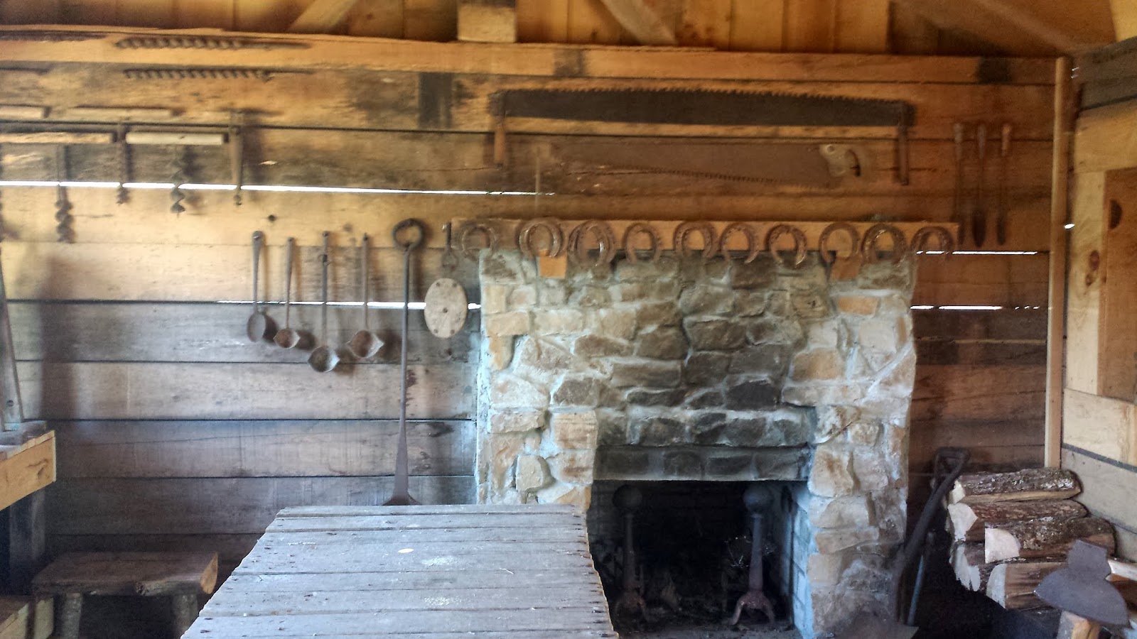
This
photo is of the inside of the blacksmith’s shop. The tack shop is right next door.
The
early records regarding the fort's construction were destroyed in a fire but historians
have determined that the fort was completed by federal troops under the command
of Captain John Wade and Captain Richard Sparks in July 1797. The fort was originally referred to as
"Fort Butler" after Lieutenant-Colonel Thomas Butler (commander of
federal forces in East Tennessee), but the name had been changed to "Fort
Southwest Point" by 1798.

Based on the map of the fort, we believe that this is a second barracks under
construction…
Lieutenant-Colonel
Butler moved his headquarters to Fort Southwest Point in 1799, when nine
companies (7 infantry, 1 artillery, and 1 dragoon) totaling roughly 400-500
troops were garrisoned at the fort. Around
the same time, nearby lots had been sold for what eventually became the city of
Kingston. It was named for Major Robert
King, an officer stationed at the fort.

This
shelter with an old time outdoor oven is just one more feature of the
fort. When special events are staged at
the fort, history comes to life with interpreters dressed in period
costumes.
Historical
Footnote:
· One might assume that the primary mission
for the fort and its garrison was to protect settlers. Actually at first it was more to provide escort
service across Cherokee territory. A
prime portion of the mission was to ensure that travelers did not illegally
settle on Cherokee owned lands. In
addition, the troops began to further protect Cherokee rights by forcibly
removing white settlers who had illegally settled on Cherokee lands. Much to the sorrow of the Cherokee, that
mission for the troops didn’t last long…

This is
a frontal view of the tack shop (left) and the blacksmith shop (right) with the
palisade walls in the background.
Historical
Footnotes:
· Fort Southwest Point was Roane County
Tennessee’s first post office.
· The first Indian School was located at the
fort. In the late eighteenth century,
reformers starting with Washington and Knox, in efforts to "civilize"
or otherwise assimilate Native Americans (as opposed to relegating them to
reservations), adopted the practice of educating native children in current
American culture, which was at the time largely based on rural agriculture,
with some small towns and few large cities.
· In 1801, Fort Southwest Point’s importance increased
when the roles of Agent of the War Department for Tennessee and Cherokee Indian
Agent were combined with Fort Southwest Point being chosen as headquarters for
this dual function. Colonel Return
Jonathan Meigs was chosen for this important role. By all accounts he was a fair-minded man, who
took his responsibilities seriously. In
response to the Cherokee’s complaint that their annuity for the lands they
seceded had been paid in relatively useless luxury goods, Meigs ensured the
payments took the form of tools, livestock and goods to help their economic situation.
Fort
Southwest Point is located at 1226 S Kentucky Street, (TN Hwy 58), in Kingston
Tennessee. Phone: 865-376-6584. The fort’s website can be found at http://www.southwestpoint.com/.
Just
click on any of the photos to enlarge them…
Thanks
for stopping by for a short history lesson!
Take
Care, Big Daddy Dave
I learn a lot about our area from you and I've lived here for nearly 50 yrs
ReplyDeleteDave, what a delight to see your post in my news feed today! I really enjoy your posts, the information and photos that you share are fun, fascinating and I learn a lot. I love the little chapel!!! Thank you so much for sharing.
ReplyDelete