Departing
from Killarney, we headed generally north with a diversion west to Dingle. While our eventual goal for the day was the
village of Doolin in County Clare, we wanted to explore the countryside a bit
along the way.

We
cruised along N72 to N70 and through the town of Castlemaine where we picked up
H561 west toward Dingle. As you can see
it was an overcast day but with the mountains, water, green grass of
Ireland…and the sheep, it was still very scenic.

I believe
that the peaks in the distance are the Slieve Mish Mountains. This range of mountains is only about 4.3
miles wide and 11.8 miles long. They
overlook Tralee Bay on the north side of the Dingle Peninsula and Dingle Bay on
the south. The tallest peak in the range
reaches 2,792 feet. These mountains are
named for “Sliabh Mish”, a mythological Celtic princess who was reputed to be
very cruel…

Along the
way, Laurie took this photo of a lonely but sturdy looking horse just standing
near the road…She said it was a Irish Cob.

As we moved
west toward Dingle, we came to an extensive beach area facing Dingle Bay. Inch Beach is a sand spit that juts out in
the sea between the Bay and Castlemaine Harbor.
Portions of the 1970 movie, “Ryan’s Daughter”, starring Robert Mitchum
and Sarah Miles was filmed here. It was
nominated for 4 Academy Awards, winning 2 of them.

Despite
the fact that it was late September, very windy and cool with an occasional
spit of rain, there were quite a few folks wandering around on Inch Beach. As you can see, this is a big long
beach. It’s actually over 3 miles
long!

This is a
westerly view along the Dingle Peninsula from one of the car park areas. The surf was really pounding the shoreline
and that wind was howling…
Dunmore
Head, west of the town of Dingle, is the westernmost point of Ireland and
arguably Europe as well.
Many of the
people living on Dingle Peninsula, especially the western end of it, are Gaelic
speaking. The peninsula is commonly
called ‘Corca Dhuibhne’ which means “seed or tribe of Duibhne”, from the
“tuath’ people of Corco Dhuibhne who occupied the area in the Middle Ages.

In this
photo you can see the other side of the Inch Beach peninsula and Castlemaine
Harbor. Sammy’s Restaurant is
conveniently located right next to the beach.
When I
checked Sammy’s on the Internet, I discovered that, in addition to the
restaurant, they operate the Inch Lodge with 11 bed and breakfast rooms plus 9
freestanding self-catering cottages. I
also noted that only 3% of the 304 reviews of the restaurant on TripAdvisor
rated the restaurant poor or terrible…that’s a very positive ratio of
Excellent/Very Good/Average vs. negative findings. For more about Sammy’s restaurant and their varied
offerings for a stay on Inch Beach go to http://www.inchbeach.com/index.php.

From
Inch, we followed R561 to N86 west. The
scenery was terrific despite the clouds!
The road passed along the southern edge of some mountains along the
western portion of the Dingle peninsula that for some reason are unnamed. One of the peaks in this range is over 3,100
feet high…

Ahhh…the
green, green grass of Ireland! We loved
the patterns created by the fields…

Here’s
one more photo showing the beautiful fields and pastures for the sheep. There are plenty of them just in this
picture!
A 2013
study said that there were about 4,750,000 sheep in Ireland. That compares to a human population of
4,770,000! More startling to me was the
fact that the same study said that there were 6,600,000 cattle in Ireland… By
international standards, Ireland’s sheep flocks tend to be small scale
operations with half of them having less than 50 ewes. In Scotland, the average flock has over 200
ewes and in New Zealand, the average flock totals 1,400!

It was
still cloudy when we arrived in the town of Dingle. Like most Irish towns and villages, Dingle is
a colorful place! From right to left, we
have: the Dingle Bay Hotel/Paudie’s Bar (http://www.dinglebayhotel.com/bar.html);
Leac A’ Re Crafts (https://www.facebook.com/LEAC-A-RÉ-595210777176801/);
Murphy’s Ice Cream (http://www.murphysicecream.ie/);
Danno’s Bar and Restaurant (http://dannos.ie/); The Dingle Woollen
Company (no website), and; John Benny’s Pub (http://www.johnbennyspub.com/).
So many
things to do and places to eat…and so little time!
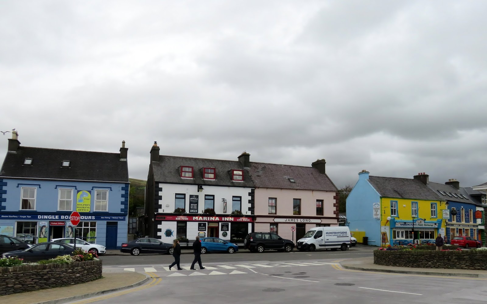
Here’s
another view of the center of Dingle.
Dingle Boat Tours are at the left…and they offer a wide a variety of options…that would
have been fun! (https://dingleboattours.com/index.php/tours)
Next to that is the Marina Inn (http://www.themarinainndingle.com/)
and then a building that was up for sale.
That is followed by Harrington’s Family Restaurant…the blue and yellow building
on the right. (No website or Facebook posting)

Of
course, given my love of boats and the water in general, I had to go down to
the pier and take some photos of a few fishing boats. From what I could see, the boat at the right
front is named 'Rosses Fisher'. The white
boat next to it is the 'Fasnet Fisher'. I
gave up trying to research their history… However, the larger red trawler-netter
behind the Fasnet Fisher is the 'Star of David', which is registered in Cork
Ireland.

This is a
view of Dingle across the harbor… Unfortunately, we were on a ‘mission’ with
specific goals for the day and if we strayed much from our agenda, we’d miss
some serious highlights planned for the day.
Dingle, with a population of about 2,000, is
the only town on the Dingle Peninsula.
No surprise…the primary industries are tourism, fishing and
agriculture. The town was developed as a
port following the Norman invasion of Ireland.
By the 1200s more goods were being exported through Dingle than through
Limerick. By the 1300’s, the importing
of wine was a major business. By the
1500s, Dingle was one of Ireland’s main ports, exporting fish and hides and
importing wines. Both the French and Spanish
fishing fleets used the town as a base of operations…

…just one
more photo of a fishing vessel. This is
the Lady Laura entering the harbor at Dingle.
I just liked this photo with the green hills in the background.
To learn
more about the town of Dingle and the popular Dingle Peninsula, you can go to http://www.dingle-peninsula.ie/.
For many colorful images of this very
attractive tourist town, go to https://www.bing.com/images/search?q=dingle+town&id=6B98A664A0261397B8D172B7DAD16C5A78DB1A8C&FORM=IARRTH.
To view the beauty of the Dingle Peninsula in
general, there are a plethora of photos found at https://www.bing.com/images/search?q=dingle+peninsula&id=C923C7168BD91E0F92B97D8B1A94579701FA40FD&FORM=IQFRBA.
Next time…on
to the Cliffs of Moher and the village of Doolin.
Just
click on any of the photos to enlarge them.
Thanks
for stopping by for a visit!
Take
Care, Big Daddy Dave
No comments:
Post a Comment