…continuing on our July road trip through northern and western Nebraska.


Along the way, we noted a large irrigation canal running roughly parallel to the highway. I have since learned that there are several canal systems supporting farmers in central Nebraska. This particular concrete lined waterway is the Ainsworth Canal and it’s managed by the Ainsworth Irrigation District. The principal crops being irrigated are feed grains, alfalfa and small grains.
It should
be noted that this area of Nebraska is considered to be semi-arid with only an
average of 21 inches of annual rainfall as compared to an average of 38 inches
for the entire USA.

Of course I had a couple destinations in mind. The first one was the Merritt Reservoir. The Merritt Dam is a 126 foot tall earthen dam that impounds the Snake River. The dam was finished in 1964 as a project of the United States Bureau of Reclamation. The reservoir holds almost 75,000 acre-feet of water covering 3,000 surface acres and it has about 44 miles of shoreline.
The
reservoir is a popular place for fishing and water sports. Those activities are administered by the
Nebraska Game and Parks Commission. I
found photos on-line displaying some very large catfish and walleye that were
caught at the Merritt Reservoir. To
learn more about the recreation possibilities go to: http://outdoornebraska.gov/merrittreservoir/.


The Sandhills is an area or region of mixed-grass prairie on grass-stabilized sand dunes located in north-central Nebraska. These dunes cover a bit over 25% of the state. That is an area about the equivalent to the size of Maryland and Vermont combined.
The
Sandhills were formed from sediment eroded from the Rocky Mountains by the
Pleistocene glaciers. Between 5,000 and
8,000 years ago, wind sculpted the fine grains of primarily quartz sand into
dunes as much as 20 miles long and 400 feet high. Today the dunes are held in place by grass
but they are the largest sand dune formation in the USA.
Note: Cherry County and this region of Nebraska
averages an altitude of 3,200 feet above sea level.

Another lonely road across the prairie… Passing along the north side of the Merritt Reservoir, we followed NE Hwy 16F west and then north back toward US Hwy 20. Along this route we passed through the Samuel R. McKelvie National Forest. The forest covers 116,079 acres and it’s managed as part of the U.S. Forest Services' Nebraska National Forests and Grasslands.
The
forest is a combination of prairie grasslands and pine forest ‘islands’. Most of the forested areas were planted by
hand over the past 75 years. I found it
interesting that the protein content of the native grasses are among the
highest found anywhere in the world.
Many lease options for grazing cattle are provided for ranchers in the
area…

Although rainfall in this area is limited, the rain that does fall soaks quickly into the permeable soil. The Sandhills sits on top of the massive Ogallala Aquifer and as a result, temporary and permanent shallow lakes are common in low-lying valleys between the stabilized dunes. The aquifer underlies parts of 8 states, about 174,000 square miles…bigger than the entire state of California…stretching from New Mexico and Texas all the way to Wyoming and South Dakota.


Other than smaller birds, the only animals we saw during this portion of our drive were that pair of swans and a few small flocks of geese. While I’m fairly sure that the geese are Canadian Geese and not Brant’s Geese…they do look a lot alike with the Canadian variety, being significantly larger. As for the swans, I’d like to believe that those are Trumpeter Swans and not their smaller look-alikes, Tundra Swans. We were too far away to be absolutely sure but a map of their range clearly shows that this area of Nebraska is part of the Trumpeter Swan's range.
The
sandhills are populated with a great variety of birds, reptiles, fish and
mammals. The latter include muskrats,
porcupines, beaver, prairie dogs, coyotes, fox, skunks, raccoons, badgers,
mink, otter, bobcat, pronghorn antelope, whitetail deer, mule deer and a
scattering of elk. The World Wide Fund
for Nature has designated the Sandhills as an ecoregion, separate from the
other grasslands of the Great Plains. As
per their findings, as much as 85% of the region is intact natural
habitat. This is because most of the
Sandhills lands has never been plowed.


I was unable to identify this beautiful wildflower…but obviously that bee loves it! The Sandhills has a diverse insect population. They have adapted to the various habitats with the sandy soil and dry climate. Pollinators include wild bees, bumblebees, moths and wasps. The Monarch Butterfly, now an endangered species, migrate through the Sandhills on their 2000 mile journey to winter habitat in the Mexico.

Soon after departing the National Forest, we once again crossed over the Niobrara River. The name of the river is of Omaha and Ponca Indian origin. It means ‘running (or spreading) water’. The Niobrara has a more uniform…year around…flow of water than do most plains streams. This is due to steady contributions from groundwater and various tributaries. The river is about 430 miles long.
The river
is home to over 500 plant species, many existing at the edge or beyond their
usual range. Some species aren’t naturally
found within several hundred miles of this area. The scenic river is spanned by 15 bridges,
six of which are listed on the National Register of Historic Places. The canyons and narrow valleys created by the
river provide different ecological environments for a great variety of plants…

Shortly after rejoining US Hwy 20, we stopped by the town of Cody Nebraska. Most folks would assume that the town was named after the famous “Buffalo Bill” Cody, but actually this town was named after Thomas Cody, foreman of an 1884 railroad camp crew. Until a post office was established in the new railroad depot, Tom Cody’s shack served as the area’s communication center.

Cody was of course founded with the coming of the railroad. However it never grew very much. At its peak in 1920, the town had a population of 428…but now residents only number about 153. At least the Security First Bank is utilizing the old Cody Motor Company building…
Back in
the day, beginning with the murder of a rail camp resident by a ranch cowboy,
Cody was a wild place. Some deaths weren’t
even investigated and arson was the most favored way to eliminate business competition. The town became known as a gambling and
bootlegging center… A train carload of sugar a week was used to manufacture
moonshine. “Cody Hootch” was delivered
far and wide.
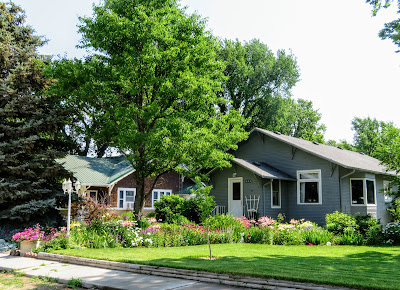

It is said that the town is now so small that Google ‘Streetview’ just drove by the community…but folks continue to live here despite its relative isolation about 40 miles west of Valentine. These homes were well maintained with the first one being complete with a beautiful flower garden.
Actually,
Cody’s town motto is “A Town Too Tough To Die”.
By way of
example, there is Cody’s grocery store.
Usually when a town’s only grocery store closes, it’s about the end of
the line for that town. Not for Cody!
In 2008, the town banded together to bring back a grocery store…not
as a profit making entity but rather as a hands-on learning tool for students in
the Cody-Kilgore school district and as a much needed service for residents. With the help of community volunteers, grants
and donations, the non-profit store opened in 2013.
Students of all ages have been involved with the project since it was
started. They stock the shelves, work
the checkout lines, analyze finances and maintain the store’s website. Despite the non-profit nature of the
operation, the store couldn’t continue to operate without the students.
Circle-C
Market website: http://www.circlecmarket.com/welcome.html. Facebook: https://www.facebook.com/circlecmarketincody/.

I thought that it would be appropriate to end this post with Laurie's photo of a small herd of beautiful horses with the prairie grass covered sandhills of Nebraska in the background… I feel calm just looking at this photo and Laurie…well…she just loves horses!
Just
click on any of the photos to enlarge them…
Thanks
for stopping by for a visit!
Take
Care, Big Daddy Dave
That long and lonely road across the prairie looks really nice and well maintained. I am glad that the students saved the grocery store of Cody’s town. The horses look magnificent!
ReplyDeleteI've not been in this area and I'm impressed with the rolling grasslands. I learned there are at least two Snake Rivers. I'm enjoying your trip.
ReplyDeleteVery interesting post...I had not known about the sand hills of Nebraska before. Loved that the students keep the store running in Cody...I dare say they are volunteer help!
ReplyDeleteI love these little towns David and all these beautiful horses, I love them , take care ! hugs
ReplyDeleteThose long stretches of roadway with not a car in sight are what amazed me, Dave. It reminded me of our cross country trip when we saw similar roads, especially in ND. That was amazing to read about the town of Cody and the sole grocery store being run by students. Sure hope it continues for the residents living there.
ReplyDeleteBeautiful places, I love the lakes and the animals. We have the sea nearby, it's only 10 minutes by bus, or even less, but it's been too hot to go there. I haven't been to the beach at all this summer, it was too hot. I went there last Friday for a walk but I was almost blown away by the way ... it was something like 40 kilometers an hour. I had to take shelter in a cafe... my favorite place as you know.
ReplyDelete